1950s Maps of Clipper Bay, Franklin County
Explore 3 historic maps of Clipper Bay from the 1950s. These maps offer a rare glimpse into what life looked like during the 1950s — showing old roads, neighborhoods, homes, and landmarks that have changed or disappeared over time.
Whether you're researching your family's past, planning a metal detecting trip, or studying how Clipper Bay's landscape evolved across the 1950s, these high-resolution maps are a powerful tool for exploring the history of this region.
- Focus on a specific era: All maps on this page are from the 1950s, giving you a focused view of this time period.
- See what’s changed: Compare century-old streets, trails, and buildings to today's modern landscape using overlays and satellite layers.
- Research with precision: Use these maps for genealogy, historical research, land use analysis, or educational projects.
- View, download, or print: Maps are fully viewable online in high resolution, and can be downloaded or printed for your own records.
Start exploring Clipper Bay's history through authentic maps from the 1950s. This is your window into the past.
Clipper Bay, Franklin County maps
(3)- 1950 Map of Goose Island
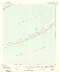 1950 Goose Island1950 Print · USGSThe Franklin County coast comes alive in the mid-century, showing the quiet settlement of Eastpoint and the long, sandy stretches of St George Island. Genealogists and maritime historians can trace coastal landmarks like Eastpoint Cem, Old Landing, and Goose Island.4 unique versions available
 - 1957 Map of Apalachicola, 1968 Print
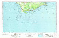 1957 Apalachicola1968 Print · USGSFlorida's Forgotten Coast comes alive in this mid-century portrait of timber, fishing, and military outposts. Researchers can trace the waterfronts of Apalachicola, the grounds of Fort Gadsden, and the early footprint of Mexico Beach before modern development.2 unique versions available
 - 1959 Map of Apalachicola
 1959 Apalachicola1959 Print · USGSThe Florida Panhandle's coastline is captured in the late fifties, showcasing the maritime and rail connections between Port St Joe and the oyster-rich waters of Apalachicola. Researchers can trace the legacy of Fort Gadsden or locate historic rail stops like Lanark Station and McIntyre along the coast.
End of results
Showing maps 1-3 of 3
Frequently asked questions
- What are the different types of historical maps available for Clipper Bay?
- What is the oldest map of Clipper Bay?
- Where can I purchase historical maps of Clipper Bay for my home or office?
- Where can I download high-res historical maps of Clipper Bay?
- Are there historical topographic maps available for Clipper Bay?
- Is there historical aerial imagery available for Clipper Bay?
- Where are historical maps of Clipper Bay sourced from?