1950s Maps of Hernando County, Florida
Explore 18 historic maps of Hernando County from the 1950s. These maps offer a rare glimpse into what life looked like during the 1950s — showing old roads, neighborhoods, homes, and landmarks that have changed or disappeared over time.
Whether you're researching your family's past, planning a metal detecting trip, or studying how Hernando County's landscape evolved across the 1950s, these high-resolution maps are a powerful tool for exploring the history of this region.
- Focus on a specific era: All maps on this page are from the 1950s, giving you a focused view of this time period.
- See what’s changed: Compare century-old streets, trails, and buildings to today's modern landscape using overlays and satellite layers.
- Research with precision: Use these maps for genealogy, historical research, land use analysis, or educational projects.
- View, download, or print: Maps are fully viewable online in high resolution, and can be downloaded or printed for your own records.
Start exploring Hernando County's history through authentic maps from the 1950s. This is your window into the past.
Hernando County, FL maps
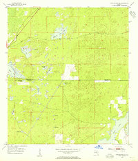
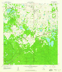
(18)- 1954 Map of Spring Lake, 1955 Print
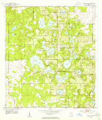 1954 Spring Lake1955 Print · USGSThe Hernando and Pasco county line in the mid-1950s reveals a landscape of high-ground settlements and numerous interior lakes. Genealogists and researchers can locate old landmarks like the Townsend House Cem, Mt Pleasant Ch, and Bay Spring Sch.5 unique versions available
 - 1954 Map of Chassahowitzka Bay, 1955 Print
 1954 Chassahowitzka Bay1955 Print · USGSThe Florida Gulf Coast in the mid-fifties reveals an intricate wilderness of tidal creeks and limestone islands. Researchers can navigate the complex labyrinth of the Chassahowitzka National Wildlife Refuge, tracing features like Seven Cabbage Island and Chub Creek.4 unique versions available
 - 1954 Map of Brooksville NW, 1955 Print
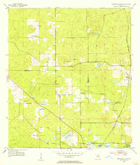 1954 Brooksville NW1955 Print · USGSFlorida's Nature Coast transition in the 1950s is detailed here along the Citrus and Hernando county line. Genealogists and researchers can trace rural life through landmarks like Stage Pond Cem, Hebron Ch, and the Stafford Siding rail stop.4 unique versions available
 - 1954 Map of Nobleton, 1955 Print
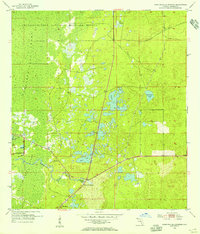
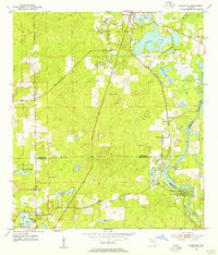 1954 Nobleton1955 Print · USGSThe Citrus and Hernando county line comes alive in the mid-fifties, showing a landscape shaped by the phosphate industry and the Withlacoochee River. Genealogists can locate family landmarks like Frazier Cem and the Story Mine near Floral City.3 unique versions available
 - 1954 Map of Brooksville, 1955 Print
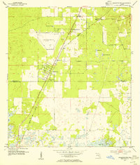
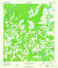
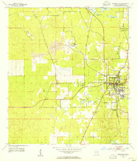 1954 Brooksville1955 Print · USGSThe Hernando County seat and its surrounding phosphate and lime industries are documented here in the mid-fifties. Researchers can trace the early layout of Brooksville, the rural siding at Tooke Lake Junction, and the terrain of the Chinsegut National Wildlife Refuge.4 unique versions available
 - 1954 Map of Aripeka, 1955 Print
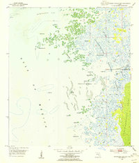
 1954 Aripeka1955 Print · USGSThe Aripeka coast in the mid-fifties is a maze of tidal bayous and hammock islands at the county line. Researchers can trace the early layout of Aripeka and find nearby landmarks like Hunters Lake, Bathhouse Island, and the Devils Rock Yard.4 unique versions available
 - 1954 Map of Chassahowitzka, 1955 Print
 1954 Chassahowitzka1955 Print · USGSCoastal Florida's Nature Coast is captured in the mid-fifties, showing the intersection of dense hammock lands and sprawling tidal marshes. Trace the original footprints of Chassahowitzka and navigate the intricate waters of the Chassahowitzka River and Blind Creek.4 unique versions available
 - 1954 Map of Bayport, 1955 Print
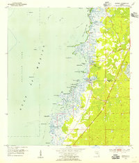
 1954 Bayport1955 Print · USGSCoastal Hernando County is shown in the mid-fifties as a wild expanse of tidal marsh and spring-fed rivers. Local historians can trace early settlements at Bayport and Cooglers Beach, alongside the intricate waterways of Mud River Spring and Jenkins Creek.5 unique versions available
 - 1954 Map of Masaryktown, 1955 Print
 1954 Masaryktown1955 Print · USGSCoastal Hernando and Pasco Counties are captured here in the mid-fifties, centered on the unique immigrant farming colony of Masaryktown. Genealogists and local historians can trace the early layout of Garden Grove, locate the McGeachy Cem, and follow the Seaboard Air Line rail corridor.3 unique versions available
 - 1954 Map of Brooksville SE, 1955 Print
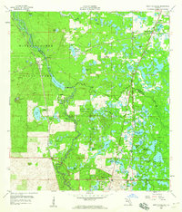
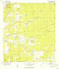 1954 Brooksville SE1955 Print · USGSSoutheast of Brooksville in the mid-fifties, this landscape reveals a busy intersection of wildlife conservation and heavy phosphate or limestone mining. Researchers can locate the Brooksville Cem, trace the Atlantic Coast Line, and find rural landmarks like St Louis Ch and Tucker Hill.3 unique versions available
 - 1954 Map of Weekiwachee Springs, 1955 Print
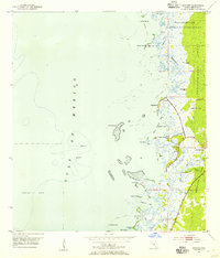
 1954 Weekiwachee Springs1955 Print · USGSHernando County is captured in the mid-fifties, showing the coastal transition from upland ponds to the Gulf marshes. Map collectors and historians can trace the course of the Weekiwachee River and locate the small settlement at Berkeley.3 unique versions available
 - 1954 Map of Port Richey NE, 1955 Print
 1954 Port Richey NE1955 Print · USGSThe rural boundary between Hernando and Pasco Counties is shown in the mid-1950s, defined by its unique karst landscape of sinks and wet prairies. Genealogists and local historians can locate Loyce Cem and trace seasonal water bodies like Weekiwachee Prairie Lake or Rock Sink.4 unique versions available
 - 1955 Map of Plant City, 1966 Print
 1955 Plant City1966 Print · USGSMid-century Central Florida comes to life in this survey of the Nature Coast and the inland citrus and rail belt. Genealogists and historians can trace the paths of the Atlantic Coast Line, locate the Anclote Keys Lighthouse, or find old communities like Masaryktown and Lacoochee.6 unique versions available
 - 1958 Map of Plant City
 1958 Plant City1958 Print · USGSFlorida's Gulf Coast and inland ridge country are captured here in the mid-fifties, showing the region before modern sprawl. Genealogists and historians can trace rail-era towns like Richland and Trilby or locate coastal landmarks such as the Anclote Keys Lighthouse.
 - 1958 Map of Webster, 1959 Print
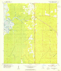
 1958 Webster1959 Print · USGSSumter and Hernando counties are captured here in the late fifties, showing a landscape of cypress swamps and frontier settlements. Researchers can locate family landmarks such as Mt Olive Ch, trace the Atlantic Coast Line rail route through Linden, and explore the northern reaches of the Withlacoochee State Forest.2 unique versions available
 - 1958 Map of Wahoo, 1960 Print
 1958 Wahoo1960 Print · USGSSumter County was a landscape of intricate wetlands and rail-line settlements during the late fifties. Researchers can trace the proximity of Wahoo to the Seaboard railroad or locate historic sites like Dade Battlefield Memorial State Park and Pleasant Hill Ch.2 unique versions available
 - 1958 Map of Saint Catherine, 1960 Print
 1958 Saint Catherine1960 Print · USGSRailroad junctions and river bottomlands meet in this late 1950s study of the Sumter and Hernando county line. Genealogists and historians can trace the rail sidings of Saint Catherine, find rural landmarks like Little Rock Ch, or locate the old Phosphate Pit and Quarry sites.3 unique versions available
 - 1959 Map of Plant City
 1959 Plant City1959 Print · USGSThe West Florida coast and inland timberlands are captured here in the late fifties, from the bend of the Gulf to the rail hubs of the interior. Trace the paths of the Atlantic Coast Line through Inverness and find landmarks like the Anclote Keys Lighthouse.
End of results
Showing maps 1-18 of 18
Top cities of Hernando County
- Spring Hill historical maps
- Brooksville historical maps
- South Brooksville historical maps
- Weeki Wachee historical maps
Frequently asked questions
- What are the different types of historical maps available for Hernando County?
- What is the oldest map of Hernando County?
- Where can I purchase historical maps of Hernando County for my home or office?
- Where can I download high-res historical maps of Hernando County?
- Are there historical topographic maps available for Hernando County?
- Is there historical aerial imagery available for Hernando County?
- Where are historical maps of Hernando County sourced from?