1990s Maps of Weekiwachee Woodlands, Florida
Explore 1 historic maps of Weekiwachee Woodlands from the 1990s. These maps offer a rare glimpse into what life looked like during the 1990s — showing old roads, neighborhoods, homes, and landmarks that have changed or disappeared over time.
Whether you're researching your family's past, planning a metal detecting trip, or studying how Weekiwachee Woodlands's landscape evolved across the 1990s, these high-resolution maps are a powerful tool for exploring the history of this region.
- Focus on a specific era: All maps on this page are from the 1990s, giving you a focused view of this time period.
- See what’s changed: Compare century-old streets, trails, and buildings to today's modern landscape using overlays and satellite layers.
- Research with precision: Use these maps for genealogy, historical research, land use analysis, or educational projects.
- View, download, or print: Maps are fully viewable online in high resolution, and can be downloaded or printed for your own records.
Start exploring Weekiwachee Woodlands's history through authentic maps from the 1990s. This is your window into the past.
Weekiwachee Woodlands, FL maps
(1)- 1999 Map of Port Richey NE, 2002 Print
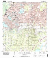 1999 Port Richey NE2002 Print · USGSHernando and Pasco counties at the close of the century show a region transitioning from karst wetlands to suburban centers. Researchers can trace the development of neighborhood schools like Floyd Elementary School or locate family sites near Loyce Cem and Crews Lake.
End of results
Showing maps 1-1 of 1
Top cities near Weekiwachee Woodlands
- Spring Hill historical maps
- Bayonet Point historical maps
- Hudson historical maps
- Brooksville historical maps
- South Brooksville historical maps
- Port Richey historical maps
See more
Frequently asked questions
- What are the different types of historical maps available for Weekiwachee Woodlands?
- What is the oldest map of Weekiwachee Woodlands?
- Where can I purchase historical maps of Weekiwachee Woodlands for my home or office?
- Where can I download high-res historical maps of Weekiwachee Woodlands?
- Are there historical topographic maps available for Weekiwachee Woodlands?
- Is there historical aerial imagery available for Weekiwachee Woodlands?
- Where are historical maps of Weekiwachee Woodlands sourced from?