1990s Maps of Waddells Mill, Florida
Explore 1 historic maps of Waddells Mill from the 1990s. These maps offer a rare glimpse into what life looked like during the 1990s — showing old roads, neighborhoods, homes, and landmarks that have changed or disappeared over time.
Whether you're researching your family's past, planning a metal detecting trip, or studying how Waddells Mill's landscape evolved across the 1990s, these high-resolution maps are a powerful tool for exploring the history of this region.
- Focus on a specific era: All maps on this page are from the 1990s, giving you a focused view of this time period.
- See what’s changed: Compare century-old streets, trails, and buildings to today's modern landscape using overlays and satellite layers.
- Research with precision: Use these maps for genealogy, historical research, land use analysis, or educational projects.
- View, download, or print: Maps are fully viewable online in high resolution, and can be downloaded or printed for your own records.
Start exploring Waddells Mill's history through authentic maps from the 1990s. This is your window into the past.
Waddells Mill, FL maps
(1)- 1994 Map of Cottondale East, 1995 Print
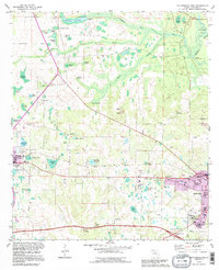 1994 Cottondale East1995 Print · USGSJackson County in the mid-nineties shows the evolving landscape between the growing town of Marianna and the rural crossroads of Cottondale. Genealogists can trace old family sites near Speights Cem, the historic Bellamy Bridge, or the riverside Christoff Ferry Landing.
End of results
Showing maps 1-1 of 1
Top cities near Waddells Mill
- Marianna historical maps
- Chipley historical maps
- Graceville historical maps
- Malone historical maps
- Rehobeth historical maps
- Cottonwood historical maps
See more
Frequently asked questions
- What are the different types of historical maps available for Waddells Mill?
- What is the oldest map of Waddells Mill?
- Where can I purchase historical maps of Waddells Mill for my home or office?
- Where can I download high-res historical maps of Waddells Mill?
- Are there historical topographic maps available for Waddells Mill?
- Is there historical aerial imagery available for Waddells Mill?
- Where are historical maps of Waddells Mill sourced from?