1940s Maps of Jewfish, Florida
Explore 2 historic maps of Jewfish from the 1940s. These maps offer a rare glimpse into what life looked like during the 1940s — showing old roads, neighborhoods, homes, and landmarks that have changed or disappeared over time.
Whether you're researching your family's past, planning a metal detecting trip, or studying how Jewfish's landscape evolved across the 1940s, these high-resolution maps are a powerful tool for exploring the history of this region.
- Focus on a specific era: All maps on this page are from the 1940s, giving you a focused view of this time period.
- See what’s changed: Compare century-old streets, trails, and buildings to today's modern landscape using overlays and satellite layers.
- Research with precision: Use these maps for genealogy, historical research, land use analysis, or educational projects.
- View, download, or print: Maps are fully viewable online in high resolution, and can be downloaded or printed for your own records.
Start exploring Jewfish's history through authentic maps from the 1940s. This is your window into the past.
Jewfish, FL maps
(2)- 1947 Map of Blackwater Sound, 1967 Print
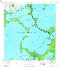 1947 Blackwater Sound1967 Print · USGSThe upper Florida Keys and the southeastern reaches of the Everglades are mapped here just after the war. Researchers can trace the early path of the Overseas Highway across Cross Key and locate early coastal landmarks like Jewfish Creek and Largo Point.3 unique versions available
 - 1949 Map of Blackwater Sound
 1949 Blackwater Sound1949 Print · USGSThe Upper Florida Keys appear here in the late 1940s, showing the early infrastructure of the Overseas Highway. Researchers can trace the original route through Cross Key and locate early coastal sites like Anglers Park and Jewfish Creek.
End of results
Showing maps 1-2 of 2
Top cities near Jewfish
Frequently asked questions
- What are the different types of historical maps available for Jewfish?
- What is the oldest map of Jewfish?
- Where can I purchase historical maps of Jewfish for my home or office?
- Where can I download high-res historical maps of Jewfish?
- Are there historical topographic maps available for Jewfish?
- Is there historical aerial imagery available for Jewfish?
- Where are historical maps of Jewfish sourced from?