1940s Maps of Sunset Point, Florida
Explore 2 historic maps of Sunset Point from the 1940s. These maps offer a rare glimpse into what life looked like during the 1940s — showing old roads, neighborhoods, homes, and landmarks that have changed or disappeared over time.
Whether you're researching your family's past, planning a metal detecting trip, or studying how Sunset Point's landscape evolved across the 1940s, these high-resolution maps are a powerful tool for exploring the history of this region.
- Focus on a specific era: All maps on this page are from the 1940s, giving you a focused view of this time period.
- See what’s changed: Compare century-old streets, trails, and buildings to today's modern landscape using overlays and satellite layers.
- Research with precision: Use these maps for genealogy, historical research, land use analysis, or educational projects.
- View, download, or print: Maps are fully viewable online in high resolution, and can be downloaded or printed for your own records.
Start exploring Sunset Point's history through authentic maps from the 1940s. This is your window into the past.
Sunset Point, FL maps
(2)- 1947 Map of Rock Harbor, 1965 Print
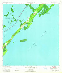 1947 Rock Harbor1965 Print · USGSUpper Key Largo in the late 1940s reveals a string of small island settlements and coastal outposts before the era of major resort expansion. Genealogists and historians can trace the foundations of Rock Harbor, find local landmarks like St Margarets Ch, or locate the specific shorelines of Tarpon Basin and Largo Sound.4 unique versions available
 - 1949 Map of Rock Harbor
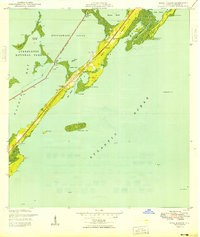 1949 Rock Harbor1949 Print · USGSUpper Key Largo in the late 1940s shows a landscape of small coastal settlements and crucial navigational markers. Trace the early footprints of Newport, Rock Harbor, and Sawyer alongside local landmarks like St Margarets Ch and the Intracoastal Waterway.2 unique versions available
End of results
Showing maps 1-2 of 2
Top cities near Sunset Point
Frequently asked questions
- What are the different types of historical maps available for Sunset Point?
- What is the oldest map of Sunset Point?
- Where can I purchase historical maps of Sunset Point for my home or office?
- Where can I download high-res historical maps of Sunset Point?
- Are there historical topographic maps available for Sunset Point?
- Is there historical aerial imagery available for Sunset Point?
- Where are historical maps of Sunset Point sourced from?