1980s Maps of Saint Michaels, Fort Defiance Agency
Explore 2 historic maps of Saint Michaels from the 1980s. These maps offer a rare glimpse into what life looked like during the 1980s — showing old roads, neighborhoods, homes, and landmarks that have changed or disappeared over time.
Whether you're researching your family's past, planning a metal detecting trip, or studying how Saint Michaels's landscape evolved across the 1980s, these high-resolution maps are a powerful tool for exploring the history of this region.
- Focus on a specific era: All maps on this page are from the 1980s, giving you a focused view of this time period.
- See what’s changed: Compare century-old streets, trails, and buildings to today's modern landscape using overlays and satellite layers.
- Research with precision: Use these maps for genealogy, historical research, land use analysis, or educational projects.
- View, download, or print: Maps are fully viewable online in high resolution, and can be downloaded or printed for your own records.
Start exploring Saint Michaels's history through authentic maps from the 1980s. This is your window into the past.
Saint Michaels, Fort Defiance Agency maps
(2)- 1983 Map of Window Rock
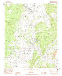 1983 Window Rock1983 Print · USGSThe Navajo Nation's capital and surrounding settlements are documented in the early 1980s, showcasing a mix of tribal governance and historic mission life. Genealogists and historians can trace institutional sites like Saint Michaels, the St Michaels Indian Sch, and the Navajo Tribal Headquarters.2 unique versions available
 - 1984 Map of Ganado
 1984 Ganado1984 Print · USGSThe Navajo Nation in the mid-eighties reveals a landscape of high mesas and vital community hubs across Apache County. Trace the development of Fort Defiance and Window Rock, or locate historic landmarks like Hubbell Trading Post and Kinlichee Boarding School.2 unique versions available
End of results
Showing maps 1-2 of 2
Top cities near Saint Michaels
- Chinle Agency historical maps
- Fort Defiance Agency historical maps
- Fort Defiance historical maps
- Window Rock historical maps
- Eastern Navajo Agency historical maps
Frequently asked questions
- What are the different types of historical maps available for Saint Michaels?
- What is the oldest map of Saint Michaels?
- Where can I purchase historical maps of Saint Michaels for my home or office?
- Where can I download high-res historical maps of Saint Michaels?
- Are there historical topographic maps available for Saint Michaels?
- Is there historical aerial imagery available for Saint Michaels?
- Where are historical maps of Saint Michaels sourced from?