1980s Maps of Tohatchi, Fort Defiance Agency
Explore 2 historic maps of Tohatchi from the 1980s. These maps offer a rare glimpse into what life looked like during the 1980s — showing old roads, neighborhoods, homes, and landmarks that have changed or disappeared over time.
Whether you're researching your family's past, planning a metal detecting trip, or studying how Tohatchi's landscape evolved across the 1980s, these high-resolution maps are a powerful tool for exploring the history of this region.
- Focus on a specific era: All maps on this page are from the 1980s, giving you a focused view of this time period.
- See what’s changed: Compare century-old streets, trails, and buildings to today's modern landscape using overlays and satellite layers.
- Research with precision: Use these maps for genealogy, historical research, land use analysis, or educational projects.
- View, download, or print: Maps are fully viewable online in high resolution, and can be downloaded or printed for your own records.
Start exploring Tohatchi's history through authentic maps from the 1980s. This is your window into the past.
Tohatchi, Fort Defiance Agency maps
(2)- 1981 Map of Gallup
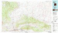 1981 Gallup1981 Print · USGSThe high desert of McKinley County comes to life in the early 1980s, centered on the hub of Gallup and its vital rail corridors. Researchers can trace the Atchison Topeka and Santa Fe line past the Fort Wingate Army Depot and through historic sites like Gamerco and the Tohatchi Trading Post.
 - 1982 Map of Tohatchi, 1983 Print
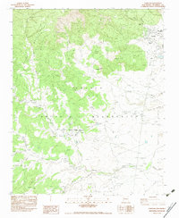 1982 Tohatchi1983 Print · USGSThe Navajo Indian Reservation comes into focus in the late seventies as desert settlements meet the slopes of the Chuska Mountains. Researchers can trace the local infrastructure and community sites of Tohatchi and Mexican Springs, including the Tse Bonita School and Cem.
End of results
Showing maps 1-2 of 2
Top cities near Tohatchi
Frequently asked questions
- What are the different types of historical maps available for Tohatchi?
- What is the oldest map of Tohatchi?
- Where can I purchase historical maps of Tohatchi for my home or office?
- Where can I download high-res historical maps of Tohatchi?
- Are there historical topographic maps available for Tohatchi?
- Is there historical aerial imagery available for Tohatchi?
- Where are historical maps of Tohatchi sourced from?