1910s Maps of Baldwin County, Georgia
Explore 2 historic maps of Baldwin County from the 1910s. These maps offer a rare glimpse into what life looked like during the 1910s — showing old roads, neighborhoods, homes, and landmarks that have changed or disappeared over time.
Whether you're researching your family's past, planning a metal detecting trip, or studying how Baldwin County's landscape evolved across the 1910s, these high-resolution maps are a powerful tool for exploring the history of this region.
- Focus on a specific era: All maps on this page are from the 1910s, giving you a focused view of this time period.
- See what’s changed: Compare century-old streets, trails, and buildings to today's modern landscape using overlays and satellite layers.
- Research with precision: Use these maps for genealogy, historical research, land use analysis, or educational projects.
- View, download, or print: Maps are fully viewable online in high resolution, and can be downloaded or printed for your own records.
Start exploring Baldwin County's history through authentic maps from the 1910s. This is your window into the past.
Baldwin County, GA maps
(2)- 1912 Map of Milledgeville
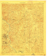 1912 Milledgeville1912 Print · USGSMilledgeville and its surroundings at the start of the century show a landscape shaped by state institutions and an expanding rail network. Researchers can trace the extensive State Sanitarium grounds or locate rural landmarks like Coleman Mill and Griffin Academy.3 unique versions available
 - 1916 Map of Irwinton, 1963 Print
 1916 Irwinton1963 Print · USGSWilkinson County is captured here in the years before the Great War, showing a network of rural settlements connected by the Central of Georgia railroad. Genealogists can trace family landmarks and community centers like Goldens Mill, Hazelino School, and Toomsboro.2 unique versions available
End of results
Showing maps 1-2 of 2
Top cities of Baldwin County
Frequently asked questions
- What are the different types of historical maps available for Baldwin County?
- What is the oldest map of Baldwin County?
- Where can I purchase historical maps of Baldwin County for my home or office?
- Where can I download high-res historical maps of Baldwin County?
- Are there historical topographic maps available for Baldwin County?
- Is there historical aerial imagery available for Baldwin County?
- Where are historical maps of Baldwin County sourced from?