1970s Maps of Bleckley County, Georgia
Explore 11 historic maps of Bleckley County from the 1970s. These maps offer a rare glimpse into what life looked like during the 1970s — showing old roads, neighborhoods, homes, and landmarks that have changed or disappeared over time.
Whether you're researching your family's past, planning a metal detecting trip, or studying how Bleckley County's landscape evolved across the 1970s, these high-resolution maps are a powerful tool for exploring the history of this region.
- Focus on a specific era: All maps on this page are from the 1970s, giving you a focused view of this time period.
- See what’s changed: Compare century-old streets, trails, and buildings to today's modern landscape using overlays and satellite layers.
- Research with precision: Use these maps for genealogy, historical research, land use analysis, or educational projects.
- View, download, or print: Maps are fully viewable online in high resolution, and can be downloaded or printed for your own records.
Start exploring Bleckley County's history through authentic maps from the 1970s. This is your window into the past.
Bleckley County, GA maps
(11)- 1973 Map of Tarversville, 1977 Print
 1973 Tarversville1977 Print · USGSTwiggs and Bleckley counties are captured in the early seventies, centered on the railroad crossing at Tarversville. Genealogists can trace family names and rural landmarks like the Shiloh Ch Cem, Twiggs County South Sch, and the Southern railroad tracks.
 - 1973 Map of Hawkinsville, 1977 Print
 1973 Hawkinsville1977 Print · USGSHawkinsville and the surrounding Pulaski County landscape are captured here in the early 1970s, as the town sits prominently on the Ocmulgee River. Researchers can trace the legacy of local families through Orange Hill Cem or locate community hubs like Baker Academy and Hartford.2 unique versions available
 - 1974 Map of Chester, 1976 Print
 1974 Chester1976 Print · USGSThe rural borderlands of Dodge and Laurens counties are captured here in the mid-seventies, centered on the community of Chester. Family historians can trace local roots through numerous landmarks like Mullis-Cole Cem, Christian Hope Ch, and Goldsboro.
 - 1974 Map of Danville East, 1976 Print
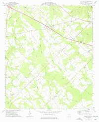
 1974 Danville East1976 Print · USGSThe railroad towns of Danville, Allentown, and Montrose anchor this mid-1970s Georgia landscape where four counties meet. Genealogists can locate rural landmarks like the Twiggs-Wilkinson Sch, Laurens Hill Ch, and the old Claypit mines.
 - 1974 Map of Danville West, 1977 Print
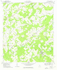
 1974 Danville West1977 Print · USGSTwiggs and Bleckley Counties are captured in the mid-seventies, showing a rural landscape defined by family cemeteries and rail-side settlements. Genealogists can locate specific landmarks like the Lizzy Harold Ch and Cem, Lucy Chapel, and the community of Cary.
 - 1974 Map of Westlake, 1977 Print
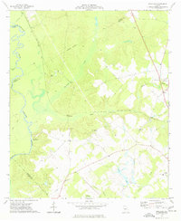 1974 Westlake1977 Print · USGSCentral Georgia’s riverfront and rail corridors are captured in the mid-1970s as they wind through the swampy lowlands of the Ocmulgee River. Researchers can trace old family footprints at Walker Cem, community hubs like Antioch Ch, and the rail stops of Westlake or Magnolia.
 - 1974 Map of Empire, 1977 Print
 1974 Empire1977 Print · USGSThe Georgia coastal plain comes into focus in the mid-seventies, showing the rail-linked communities of Empire, Frazier, and Dubois along the SOUTHERN line. Genealogists can trace local roots through numerous sites like Hart Cem, Antioch Ch, and Simmons Cem.
 - 1974 Map of Cochran, 1977 Print
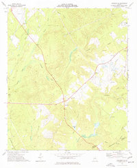
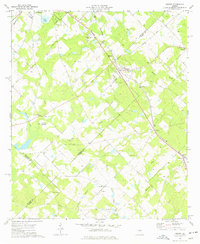
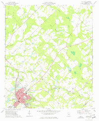 1974 Cochran1977 Print · USGSCochran and its surrounding Bleckley County countryside are shown here during the mid-seventies, featuring the growing campus of Middle Georgia College. Researchers can locate several rural landmarks including Cedar Hill Cem, Antioch Ch, and the old County Fairground.
 - 1977 Map of Hawkinsville
 1977 Hawkinsville1977 Print · USGSSouth Georgia’s agricultural and rail heartland is meticulously documented during the late seventies. Researchers can trace family ties and transit routes through old depots and towns like Unadilla, Pineview, and Hawkinsville along the Ocmulgee River.
 - 1978 Map of Hawkinsville, 1979 Print
 1978 Hawkinsville1979 Print · USGSMiddle Georgia's agricultural and rail heartland is captured here in the late seventies, showing the vital connections between the Ocmulgee River and the rural plains. Genealogists and historians can trace family locations near Vienna, Hawkinsville, or along the tracks of the Southern railroad.
 - 1978 Map of Macon, 1980 Print
 1978 Macon1980 Print · USGSCentral Georgia during the late seventies reveals a landscape shaped by military expansion and clay mining. Genealogists and local historians can trace the development of Warner Robins, the grounds of Wesleyan College, and the rural surroundings of Griswoldville.2 unique versions available
End of results
Showing maps 1-11 of 11
Top cities of Bleckley County
Frequently asked questions
- What are the different types of historical maps available for Bleckley County?
- What is the oldest map of Bleckley County?
- Where can I purchase historical maps of Bleckley County for my home or office?
- Where can I download high-res historical maps of Bleckley County?
- Are there historical topographic maps available for Bleckley County?
- Is there historical aerial imagery available for Bleckley County?
- Where are historical maps of Bleckley County sourced from?