Old Maps of Bridge Pointe at Jekyll Sound, Camden County for Hiking & Exploration
Hike through history with 11 historic maps of Bridge Pointe at Jekyll Sound. Explore old trails, ghost towns, and forgotten backroads — perfect for outdoor adventurers and local explorers.
- Rediscover forgotten places: Map out old mining camps, roads, and footpaths that no longer exist on modern maps.
- Layer with modern tools: Combine with LiDAR or satellite views to plan hikes through historical terrain.
- Made for exploration: Popular among hikers, overlanders, and local history lovers.
Use these maps to find adventure and explore the hidden past of Bridge Pointe at Jekyll Sound.
Bridge Pointe at Jekyll Sound, Camden County maps
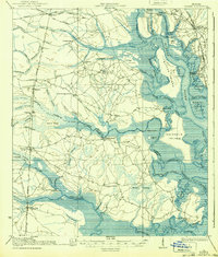
(11)- 1918 Map of Bladen
 1918 Bladen1918 Print · USGSCovers Bridge Pointe at Jekyll Sound, including Brunswick, Dock Junction, and other nearby areas2 unique versions available
 - 1939 Map of Bladen
 1939 Bladen1939 Print · USGSCovers Bridge Pointe at Jekyll Sound, including Brunswick, Dock Junction, and other nearby areas2 unique versions available
 - 1946 Map of Brunswick, 1948 Print
 1946 Brunswick1948 Print · USGSCovers Bridge Pointe at Jekyll Sound, including Savannah, Hinesville, and other nearby areas
 - 1948 Map of Brunswick
 1948 Brunswick1948 Print · USGSCovers Bridge Pointe at Jekyll Sound, including Savannah, Hinesville, and other nearby areas
 - 1956 Map of Brunswick, 1968 Print
 1956 Brunswick1968 Print · USGSCovers Bridge Pointe at Jekyll Sound, including Savannah, Hinesville, and other nearby areas2 unique versions available
 - 1961 Map of Brunswick
 1961 Brunswick1961 Print · USGSCovers Bridge Pointe at Jekyll Sound, including Savannah, Hinesville, and other nearby areas
 - 1961 Map of Dover Bluff, 1963 Print
 1961 Dover Bluff1963 Print · USGSCovers Bridge Pointe at Jekyll Sound, including Brunswick, Piney Bluff, and other nearby areas
 - 1978 Map of Brunswick
 1978 Brunswick1978 Print · USGSCovers Bridge Pointe at Jekyll Sound, including Savannah, Hinesville, and other nearby areas2 unique versions available
 - 1979 Map of Dover Bluff, 1980 Print
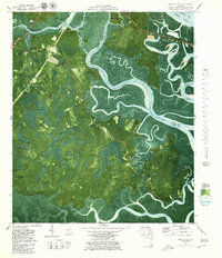 1979 Dover Bluff1980 Print · USGSCovers Bridge Pointe at Jekyll Sound, including Brunswick, Piney Bluff, and other nearby areas2 unique versions available
 - 1981 Map of Brunswick, 1982 Print
 1981 Brunswick1982 Print · USGSCovers Bridge Pointe at Jekyll Sound, including Brunswick, Saint Simons, and other nearby areas3 unique versions available
 - 1993 Map of Dover Bluff, 1995 Print
 1993 Dover Bluff1995 Print · USGSCovers Bridge Pointe at Jekyll Sound, including Brunswick, Piney Bluff, and other nearby areas
End of results
Showing maps 1-11 of 11
Frequently asked questions
- What are the different types of historical maps available for Bridge Pointe at Jekyll Sound?
- What is the oldest map of Bridge Pointe at Jekyll Sound?
- Where can I purchase historical maps of Bridge Pointe at Jekyll Sound for my home or office?
- Where can I download high-res historical maps of Bridge Pointe at Jekyll Sound?
- Are there historical topographic maps available for Bridge Pointe at Jekyll Sound?
- Is there historical aerial imagery available for Bridge Pointe at Jekyll Sound?
- Where are historical maps of Bridge Pointe at Jekyll Sound sourced from?