Old Maps of Westover, Kennesaw
Explore 39 old maps of Westover, spanning from 1890 to today. These high-resolution historic maps reveal how streets, neighborhoods, landmarks, and natural features evolved over time — perfect for genealogy, metal detecting, research, and local history exploration.
What you can do with these maps:
- See how Westover changed over time: Compare historical maps to modern-day views to trace roads, homesites, rail lines & more.
- View detailed metadata: Each map includes creators, publishers, year, scale, and archive source.
- Overlay maps with satellite & LiDAR: Visualize the past alongside modern tools to explore terrain & human change.
- Trusted historical sources: Maps sourced from the USGS, Library of Congress, and other archives.
- Access maps your way: View online, download high-res files, or order prints for personal or research use.
Start exploring old maps of Westover to uncover forgotten places, hidden landmarks, and the deep history beneath your feet.
Westover, Kennesaw maps
(39)- 1890 Map of Cartersville
 1890 Cartersville1890 Print · USGSNorthwest Georgia in the late nineteenth century was a landscape of burgeoning rail junctions and river-powered industry. Researchers can trace the roots of families and commerce at McDaniel's Station, Warford's Roads, and the many industrial sites along the Etowah River.
 - 1891 Map of Marietta
 1891 Marietta1891 Print · USGSNorth Georgia at the close of the nineteenth century is captured here as the railroad began to reshape the river-dependent landscape. Genealogists can locate family-named landmarks like Allens Mills or trace historic river crossings at Campbellton Fy and Hutchinsons Ferry.
 - 1891 Map of Cartersville
 1891 Cartersville1891 Print · USGSNorth Georgia in the late nineteenth century was defined by its winding river crossings and the arrival of the iron horse. Trace the paths of early travel through Wooley's Ferry, identify old family operations like Hall's Mill, and locate rail stops at McDaniel's Station.
 - 1895 Map of Marietta
 1895 Marietta1895 Print · USGSNorthwest Georgia in the 1890s appears as a landscape defined by the winding Chattahoochee River and the rapid expansion of iron rails. Genealogists can trace early family-named river crossings like Morris Ferry or explore the origins of Old Villarica and Bright Star.
 - 1896 Map of Cartersville
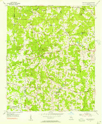
 1896 Cartersville1896 Print · USGSNorth Georgia in the late nineteenth century was a rugged landscape of river crossings and mountain ridges. Trace the old ferry routes like Akeman Ferry or locate vanished industrial sites such as Marine Mill and the early works at Cement.4 unique versions available
 - 1897 Map of Marietta
 1897 Marietta1897 Print · USGSNorthwest Georgia in the late nineteenth century was a landscape defined by river crossings and expanding rail lines. Genealogists and historians can trace defunct river crossings like Pumpkintown Ferry and old industrial sites like Daniels Mills or Beatty Switch.
 - 1901 Map of Marietta
 1901 Marietta1901 Print · USGSNorthwest Georgia at the turn of the century is a landscape of growing rail towns and vital river crossings. Researchers can trace early rural life through features like Old Villarica, Pumpkintown Ferry, and the Mount Zion Church.4 unique versions available
 - 1907 Map of Acworth, 1954 Print
 1907 Acworth1954 Print · USGSNorthern Georgia's river-and-rail corridor is captured here at the start of the twentieth century. Genealogists can trace family roots near Acworth and Kennesaw or locate old crossings like Island Mills Ferry and Steels Bridge.
 - 1909 Map of Acworth
 1909 Acworth1909 Print · USGSNorth Georgia at the turn of the century shows a landscape of river ferries and emerging rail towns before the creation of modern reservoirs. Genealogists can trace family footprints near Acworth and Woodstock, or locate historic crossings like Island Mills Ferry and Steels Bridge.
 - 1953 Map of Atlanta, 1965 Print
 1953 Atlanta1965 Print · USGSThe growing Atlanta metro and the industrial corridors of Eastern Alabama are captured here during the mid-century transition. Researchers can trace the rail-to-road shift through hubs like Anniston and La Grange or locate sites within Fort McClellan.2 unique versions available
 - 1954 Map of Lost Mountain, 1956 Print
 1954 Lost Mountain1956 Print · USGSCobb County's rural landscape is captured in the mid-1950s, showing a network of country churches and family-named roads before suburban expansion. Genealogists can locate family sites near John McEachern Sch, Corner Ch, and Red Rock.4 unique versions available
 - 1955 Map of Rome
 1955 Rome1955 Print · USGSThe tri-state borderlands of Georgia, Alabama, and Tennessee appear in the mid-fifties as a landscape of ridge-and-valley industry and river navigation. Genealogists can trace family footprints near Chattanooga, the iron works of Gadsden, and textile towns like Trion or Summerville.
 - 1956 Map of Kennesaw, 1957 Print
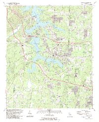
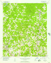 1956 Kennesaw1957 Print · USGSCobb and Cherokee counties are captured in the mid-1950s during a period of steady growth along the Louisville and Nashville rail line. Researchers can trace old property boundaries across the 20th District and locate local landmarks like Wooten Lake, Bascomb, and Chastains Lakes.5 unique versions available
 - 1956 Map of Acworth, 1957 Print
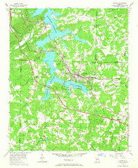 1956 Acworth1957 Print · USGSAcworth and the surrounding Cobb County hills are shown here in the mid-1950s as the reservoir changed the landscape. Trace early roads and community centers like Mars Hill Ch, the Drive-in Theater, and the Nashville Chattanooga and St Louis line.6 unique versions available
 - 1957 Map of Atlanta
 1957 Atlanta1957 Print · USGSAtlanta and the Alabama borderlands appear here in the mid-fifties, capturing the region's post-war suburban and industrial transition. Trace the development of early transport hubs and military sites like Fort McPherson, Anniston, and the Kennesaw Mountain National Battlefield Park.
 - 1958 Map of Atlanta
 1958 Atlanta1958 Print · USGSMid-century Georgia and Alabama are shown in this regional study of the corridor between the Chattahoochee River and the Appalachian foothills. Local historians can trace the development of suburban Atlanta alongside vital landmarks like Stone Mountain, Dobbins AFB, and the Seaboard Air Line rail routes.
 - 1958 Map of Rome, 1966 Print
 1958 Rome1966 Print · USGSNorthwest Georgia and neighboring Tennessee and Alabama are captured here in the late fifties, showcasing a landscape of high ridges and river valleys. Researchers can trace historic rail lines like the Seaboard Air Line RR and explore the bounds of Cloudland Canyon State Park or Fort Oglethorpe.3 unique versions available
 - 1961 Map of Rome
 1961 Rome1961 Print · USGSNorthwest Georgia and neighboring Tennessee and Alabama are shown here at a moment of significant mid-century growth. Researchers can trace the rail networks of the Central of Georgia or locate landmarks within Chickamauga and Chattanooga Nat Military Park.
 - 1963 Map of Rome
 1963 Rome1963 Print · USGSThe tri-state corner of Georgia, Alabama, and Tennessee is captured here during a period of massive reservoir expansion and post-war growth. Genealogists and historians can trace the rail corridors of the Southern Ry or locate landmarks like Fort Oglethorpe and Cloudland Canyon State Park.
 - 1981 Map of Cartersville, 1982 Print
 1981 Cartersville1982 Print · USGSNorth Georgia at the start of the eighties shows a landscape defined by massive reservoirs and historic rail corridors. Researchers can trace the heritage of the Etowah Indian Mounds or locate old junctions along the Southern Railway and Seaboard Coast Line.2 unique versions available
 - 1981 Map of Atlanta, 1982 Print
 1981 Atlanta1982 Print · USGSThe Atlanta metro area is shown during its late-century boom, following the completion of the beltway and the rise of its major international airport. Trace the growth of suburbs from Mableton to Tucker and the footprints of Fort McPherson and Stone Mtn.
 - 1992 Map of Lost Mountain, 1993 Print
 1992 Lost Mountain1993 Print · USGSCobb and Paulding counties appear here in the early nineties as suburban growth began to surround landmarks like Lost Mtn. Genealogists and historians can locate family-named landmarks and institutions such as Bullard Cem, McEachern Ch, and the Picketts Mill State Historical Site.
 - 1992 Map of Acworth, 1993 Print
 1992 Acworth1993 Print · USGSAcworth and the shores of Lake Allatoona are shown in the early nineties, a period of significant growth in Cobb County. Genealogists and local historians can locate established landmarks such as Liberty Hill Cem, Awtrey Middle Sch, and the CSX TRANSPORTATION line.2 unique versions available
 - 1992 Map of Kennesaw, 1993 Print
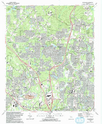 1992 Kennesaw1993 Print · USGSThe northern Atlanta suburbs were undergoing significant growth in the early nineties, centered around the rail and campus hubs of Kennesaw and Woodstock. Researchers can trace local genealogy at Old Noonday Cem and Gresham Cem or locate the historic Louisville and Nashville line.2 unique versions available
 - 2011 Map of Acworth, 2011 Print
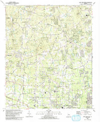
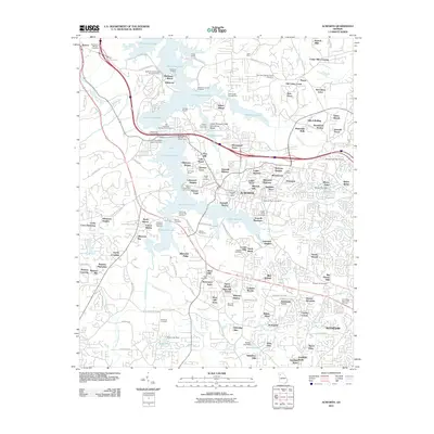 2011 Acworth2011 Print · USGSCovers Westover, including Kennesaw, Acworth, and other nearby areas
Showing maps 1-25 of 39
Frequently asked questions
- What are the different types of historical maps available for Westover?
- What is the oldest map of Westover?
- Where can I purchase historical maps of Westover for my home or office?
- Where can I download high-res historical maps of Westover?
- Are there historical topographic maps available for Westover?
- Is there historical aerial imagery available for Westover?
- Where are historical maps of Westover sourced from?