1990s Maps of Stonecrest, Georgia
Explore 4 historic maps of Stonecrest from the 1990s. These maps offer a rare glimpse into what life looked like during the 1990s — showing old roads, neighborhoods, homes, and landmarks that have changed or disappeared over time.
Whether you're researching your family's past, planning a metal detecting trip, or studying how Stonecrest's landscape evolved across the 1990s, these high-resolution maps are a powerful tool for exploring the history of this region.
- Focus on a specific era: All maps on this page are from the 1990s, giving you a focused view of this time period.
- See what’s changed: Compare century-old streets, trails, and buildings to today's modern landscape using overlays and satellite layers.
- Research with precision: Use these maps for genealogy, historical research, land use analysis, or educational projects.
- View, download, or print: Maps are fully viewable online in high resolution, and can be downloaded or printed for your own records.
Start exploring Stonecrest's history through authentic maps from the 1990s. This is your window into the past.
Stonecrest, GA maps
(4)- 1992 Map of Snellville, 1993 Print
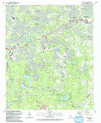 1992 Snellville1993 Print · USGSGwinnett County during the early nineties shows a landscape of growing suburbs anchored by historic family landmarks and winding river bends. Researchers can trace local genealogy through numerous sites like Hannah Cem, Annistown Cem, and the old Rock Chapel Sch.
 - 1999 Map of Redan, 2002 Print
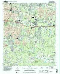 1999 Redan2002 Print · USGSDeKalb County enters a new era of growth at the turn of the century as suburban development surrounds its granite monadnocks. Researchers can trace the evolution of local communities through landmarks like Scarbrough Cross Roads, Kelleys Chapel, and Murphy Candler Sch.
 - 1999 Map of Snellville, 2003 Print
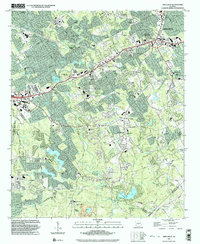 1999 Snellville2003 Print · USGSGwinnett County at the close of the century shows a landscape transitioning into a suburban hub while retaining its historic anchors. Researchers can trace family sites at Eternal Hills Cem or explore the corridor between Snellville and Annistown.
 - 1999 Map of Conyers, 2003 Print
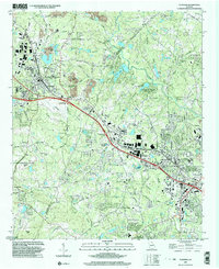 1999 Conyers2003 Print · USGSRockdale and DeKalb counties show significant suburban growth by the late nineties while preserving deep-rooted community landmarks. Genealogists can trace family footprints through numerous rural churches like New Hope Ch and landmarks such as the Bruce St Sch.
End of results
Showing maps 1-4 of 4
Top cities near Stonecrest
- Atlanta historical maps
- Sandy Springs historical maps
- Brookhaven historical maps
- Tucker historical maps
- Redan historical maps
- Chamblee historical maps
See more
Top neighborhoods of Stonecrest
- Klondike historical maps
- Browns Mill Lake historical maps
- Fairington historical maps
- Pine Mountain historical maps
- Panola historical maps
- Bramblewood historical maps
See more
Frequently asked questions
- What are the different types of historical maps available for Stonecrest?
- What is the oldest map of Stonecrest?
- Where can I purchase historical maps of Stonecrest for my home or office?
- Where can I download high-res historical maps of Stonecrest?
- Are there historical topographic maps available for Stonecrest?
- Is there historical aerial imagery available for Stonecrest?
- Where are historical maps of Stonecrest sourced from?