Old Maps of Early County, Georgia
Explore 98 old maps of Early County, spanning from 1953 to today. These high-resolution historic maps reveal how streets, neighborhoods, landmarks, and natural features evolved over time — perfect for genealogy, metal detecting, research, and local history exploration.
What you can do with these maps:
- See how Early County changed over time: Compare historical maps to modern-day views to trace roads, homesites, rail lines & more.
- View detailed metadata: Each map includes creators, publishers, year, scale, and archive source.
- Overlay maps with satellite & LiDAR: Visualize the past alongside modern tools to explore terrain & human change.
- Trusted historical sources: Maps sourced from the USGS, Library of Congress, and other archives.
- Access maps your way: View online, download high-res files, or order prints for personal or research use.
Start exploring old maps of Early County to uncover forgotten places, hidden landmarks, and the deep history beneath your feet.
Early County, GA maps
(98)- 1953 Map of Dothan, 1966 Print
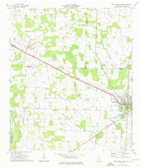
 1953 Dothan1966 Print · USGSSoutheast Alabama and Southwest Georgia are captured during a period of massive hydraulic and military expansion in the mid-fifties. Genealogists and historians can trace rural landmarks like Antioch Church and School, the Andrew Jackson Monument, and the early footprint of Fort Rucker Military Reservation.3 unique versions available
 - 1954 Map of Dothan
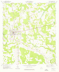
 1954 Dothan1954 Print · USGSSoutheast Alabama and Southwest Georgia are seen here in the mid-fifties, during a decade of military expansion and rural transition. Genealogists can trace the location of country schools like Little Zion School or the grounds of Kolomoki Mounds State Park.
 - 1955 Map of Dothan
 1955 Dothan1955 Print · USGSSoutheast Alabama and Southwest Georgia are captured here in the mid-fifties, showing a landscape of river-port history and growing military bases. Researchers can trace rural life via the Andrew Jackson Monument, Bauxite mines, and the Central of Georgia RR.
 - 1969 Map of Fort Gaines, 1970 Print
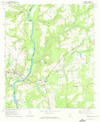
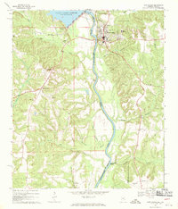 1969 Fort Gaines1970 Print · USGSThe river valley at the Alabama-Georgia line was undergoing significant change in the late sixties as the new reservoir reached its normal pool. Genealogists can trace numerous rural landmarks, from the crossroads at Shorterville to old burial grounds like Poplar Springs Cem and New Bethel Cem.2 unique versions available
 - 1970 Map of Gordon, 1972 Print
 1970 Gordon1972 Print · USGSIn the early 1970s, the river border between Alabama and Georgia balanced traditional river landings with emerging industrial infrastructure. Researchers can trace family roots through sites like St Pauls Ch and Carver Sch, or locate the Seaboard Coast Line rail corridor.3 unique versions available
 - 1970 Map of Columbia NE, 1972 Print
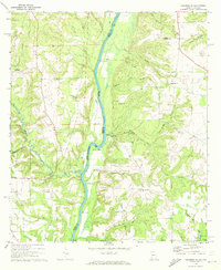 1970 Columbia NE1972 Print · USGSThe Chattahoochee River forms the border between Alabama and Georgia in this early 1970s view of the rural river valley. Researchers can trace historic river access at Gilbert Landing or locate local family landmarks like Bellevue Cem Ch and Haleburg.
 - 1970 Map of Saffold, 1972 Print
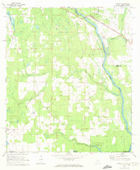 1970 Saffold1972 Print · USGSThe tri-state border of Alabama, Georgia, and Florida comes alive in the early seventies as a landscape of riverine swamps and rural hamlets. Genealogists can locate family landmarks like Pilgrims Rest Ch or trace the old rail stops at Alaga and Saffold.2 unique versions available
 - 1970 Map of Columbia, 1972 Print
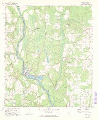
 1970 Columbia1972 Print · USGSThe Chattahoochee River corridor at the start of the 1970s shows a landscape of river-based industry and rural community life. Genealogists and historians can locate family landmarks like Grier Cem, Freeman Chapel, and the George W Andrews Lock and Dam.2 unique versions available
 - 1973 Map of Blakely North, 1975 Print
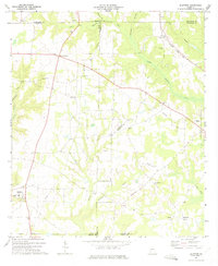
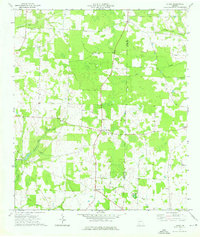
 1973 Blakely North1975 Print · USGSEarly County in the early seventies shows a landscape where ancient history meets modern rail and road networks. Genealogists can trace family roots at St Matthews Ch, Mecier Cem, or near the significant Indian Mounds of the state park.
 - 1973 Map of Bancroft, 1975 Print
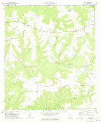
 1973 Bancroft1975 Print · USGSThe Early and Calhoun County line in the early 1970s is centered on the railroad settlement of Bancroft. Genealogists and historians can trace local landmarks like Christ Missionary Ch and Rosinwick Cem along the CENTRAL OF GEORGIA line.
 - 1973 Map of Blakely South, 1975 Print
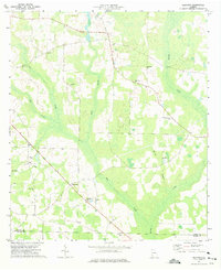
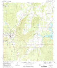
 1973 Blakely South1975 Print · USGSEarly County in the early seventies shows the southern expansion of Blakely alongside established rural crossroads. Researchers can trace family history through numerous landmarks like Jerusalem Ch, St Maryland Ch, and the crossing at Susian Ford.
 - 1973 Map of Bluffton, 1975 Print
 1973 Bluffton1975 Print · USGSBluffton and its surrounding agricultural communities in Clay County are shown here in the early seventies, just after the field checks of the previous years. Genealogists and local historians can trace the locations of Friendship Ch, County Sch No 2, and the Seaboard Coast Line railroad.
 - 1973 Map of Zetto, 1975 Print
 1973 Zetto1975 Print · USGSClay County and its neighbors in the early seventies remain a landscape of rural congregations and small agricultural hubs. Genealogists and local historians can trace the exact locations of many country landmarks, from the Clay Lookout Tower to Wesley Chapel and Harrisons Mill.
 - 1973 Map of Hentown, 1975 Print
 1973 Hentown1975 Print · USGSEarly County in the early seventies remains a landscape of small farming communities and family-named landmarks. Genealogists can trace rural life through numerous sites like Hentown, Cuba Ch, and the Houston Cem near the Miller County line.
 - 1974 Map of Damascus, 1976 Print
 1974 Damascus1976 Print · USGSIn the mid-seventies, this portion of Early County centered on the town of Damascus and the Seaboard Coast Line railroad. Local researchers can trace family landmarks like Billings Cem, Gross Cem, and the historic site of Old Damascus.
 - 1974 Map of Arlington, 1976 Print
 1974 Arlington1976 Print · USGSArlington served as a vital rail junction in Southwest Georgia during the mid-seventies, where two major lines crossed amidst a landscape of timber and agriculture. Researchers can trace rural lineages through sites like Timmons Cem, Nicholasville, and Kiokee Ch.
 - 1974 Map of Donalsonville West, 1976 Print
 1974 Donalsonville West1976 Print · USGSDonalsonville and Jakin appear at a mid-seventies crossroads of rail and river commerce along the Seminole and Early county lines. Researchers can trace rural community life through numerous landmarks like Newberry Ch, the Seaboard Coast Line tracks, and Little Hope.
 - 1974 Map of Lucile, 1976 Print
 1974 Lucile1976 Print · USGSSouthwest Georgia in the mid-seventies remained a rural landscape of scattered homesteads and county-line crossroads. Genealogists and local historians can trace family locations near Allens Chapel, the settlement at Jones Crossroads, or the waters of Howards Mill Creek.2 unique versions available
 - 1980 Map of Columbia, 1984 Print
 1980 Columbia1984 Print · USGSShelby County's civic center and surrounding hill country are captured here just as the modern era began to reshape traditional landscapes. Local historians can trace family roots at Pine Lawn Gardens and Johnson Cem or follow the rail lines through Nelson.
 - 1981 Map of Dothan, 1982 Print
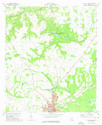
 1981 Dothan1982 Print · USGSSoutheast Alabama and the tri-state border region are shown here in the early 1980s as the area thrived on military and rail connectivity. Researchers can trace historic transit lines like the Hartford and Slocomb railroad or locate family roots in Ozark, Headland, and Geneva.
 - 1981 Map of Camilla, 1982 Print
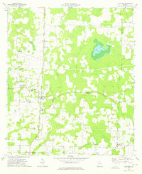
 1981 Camilla1982 Print · USGSSouthwest Georgia in the early 1980s is defined by the winding Flint River and the ancient legacy of Kolomoki Mounds State Park. Researchers can trace the agricultural and rail economy through junctions like Blakely, Pelham, and the rail lines of the Central of Georgia.2 unique versions available
 - 1981 Map of Albany, 1982 Print
 1981 Albany1982 Print · USGSSouthwest Georgia in the early eighties was a region defined by its rail hubs and winding river systems. Here you can trace the agricultural landscape from Albany to Dawson, locating sites like Radium Springs, the U S Naval Reservation, and the historic junction at Shellman.
 - 1981 Map of Troy, 1982 Print
 1981 Troy1982 Print · USGSThe Chattahoochee River valley and the wiregrass region of Alabama come alive in the early eighties as the Walter F George Reservoir reshapes the eastern border. Genealogists can trace family roots through historic railroad towns like Brundidge and Louisville or explore the rural surroundings of Blue Springs State Park.
 - 2011 Map of Saffold, 2011 Print
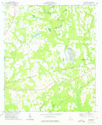
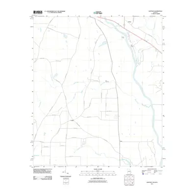 2011 Saffold2011 Print · USGSCovers Early County, including Crosby, Saffold, and other nearby areas
 - 2011 Map of Columbia, 2011 Print
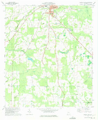
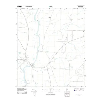 2011 Columbia2011 Print · USGSCovers Early County, including Columbia, Luke, and other nearby areas2 unique versions available
Showing maps 1-25 of 98
Top cities of Early County
Frequently asked questions
- What are the different types of historical maps available for Early County?
- What is the oldest map of Early County?
- Where can I purchase historical maps of Early County for my home or office?
- Where can I download high-res historical maps of Early County?
- Are there historical topographic maps available for Early County?
- Is there historical aerial imagery available for Early County?
- Where are historical maps of Early County sourced from?