1900s (20th Century) Maps of Elberton, Georgia
Explore 8 historic maps of Elberton from the 1900s (20th Century). These maps offer a rare glimpse into what life looked like during the 1900s — showing old roads, neighborhoods, homes, and landmarks that have changed or disappeared over time.
Whether you're researching your family's past, planning a metal detecting trip, or studying how Elberton's landscape evolved across the 1900s, these high-resolution maps are a powerful tool for exploring the history of this region.
- Focus on a specific era: All maps on this page are from the 1900s, giving you a focused view of this time period.
- See what’s changed: Compare century-old streets, trails, and buildings to today's modern landscape using overlays and satellite layers.
- Research with precision: Use these maps for genealogy, historical research, land use analysis, or educational projects.
- View, download, or print: Maps are fully viewable online in high resolution, and can be downloaded or printed for your own records.
Start exploring Elberton's history through authentic maps from the 1900s. This is your window into the past.
Elberton, GA maps
(8)- 1954 Map of Greenville, 1965 Print
 1954 Greenville1965 Print · USGSThe Upstate and Northeast Georgia are captured here during a decade of massive transformation as new reservoirs reshaped the Piedmont. Genealogists and hikers can trace the Appalachian Trail over Brasstown Bald or locate old community centers like Demorest, Westminster, and Royston.3 unique versions available
 - 1958 Map of Greenville
 1958 Greenville1958 Print · USGSThe Piedmont and Blue Ridge foothills come alive in this mid-century survey of the Upstate and Northeast Georgia. Trace the regional rail-and-river economy through the Southern Railway corridors and early reservoir developments like Lake Sidney Lanier.
 - 1958 Map of Elberton, 1959 Print
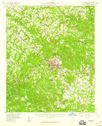 1958 Elberton1959 Print · USGSElbert County during the late fifties shows a landscape of deep-rooted rural communities and a thriving granite industry. Genealogists and local historians can locate dozens of country churches and schools like Liberty Ch and Downers Grove Sch, or trace the tracks of the Southern Railway.2 unique versions available
 - 1972 Map of Rock Branch, 1975 Print
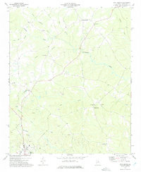 1972 Rock Branch1975 Print · USGSElbert County during the early seventies is revealed here as a landscape of rural communities and active industry. Researchers can trace family history through sites like New Bethel Ch, the settlement at Ruckersville, and the numerous Quarry labels marking the local economy.
 - 1973 Map of Elberton East, 1975 Print
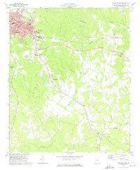 1973 Elberton East1975 Print · USGSElberton and its eastern granite country are captured here in the early seventies as the local textile and quarrying industries thrived. Researchers can locate vanished landmarks like the Drive-in Theater or trace family roots near Middleton and Fortsonia.2 unique versions available
 - 1973 Map of Elberton West, 1975 Print
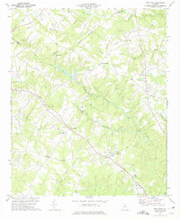
 1973 Elberton West1975 Print · USGSElbert County's granite industry and river-side settlements are shown here as they appeared in the early seventies. You can trace the SEABOARD COAST LINE through rural Oglesby and Ethridge or locate family landmarks like Antioch Ch and Central Sch.2 unique versions available
 - 1973 Map of Dewy Rose, 1975 Print
 1973 Dewy Rose1975 Print · USGSElbert and Hart County rural life in the 1970s is centered on the Southern railroad line and a network of historic country churches. Genealogists and local historians can trace family locations near Dewy Rose, Hard Cash, and Stinchcomb Ch.
 - 1979 Map of Abbeville, 1980 Print
 1979 Abbeville1980 Print · USGSThe South Carolina and Georgia borderlands are captured here during a period of significant hydroelectric development and regional growth. Researchers can trace the rail-and-river economy through the Seaboard Coast Line and landmarks like Hartwell Dam or the Silk Mills.2 unique versions available
End of results
Showing maps 1-8 of 8
Top cities near Elberton
- Hartwell historical maps
- Royston historical maps
- Iva historical maps
- Bowman historical maps
- Tignall historical maps
- Carlton historical maps
See more
Frequently asked questions
- What are the different types of historical maps available for Elberton?
- What is the oldest map of Elberton?
- Where can I purchase historical maps of Elberton for my home or office?
- Where can I download high-res historical maps of Elberton?
- Are there historical topographic maps available for Elberton?
- Is there historical aerial imagery available for Elberton?
- Where are historical maps of Elberton sourced from?