1940s Maps of Roy, Georgia
Explore 2 historic maps of Roy from the 1940s. These maps offer a rare glimpse into what life looked like during the 1940s — showing old roads, neighborhoods, homes, and landmarks that have changed or disappeared over time.
Whether you're researching your family's past, planning a metal detecting trip, or studying how Roy's landscape evolved across the 1940s, these high-resolution maps are a powerful tool for exploring the history of this region.
- Focus on a specific era: All maps on this page are from the 1940s, giving you a focused view of this time period.
- See what’s changed: Compare century-old streets, trails, and buildings to today's modern landscape using overlays and satellite layers.
- Research with precision: Use these maps for genealogy, historical research, land use analysis, or educational projects.
- View, download, or print: Maps are fully viewable online in high resolution, and can be downloaded or printed for your own records.
Start exploring Roy's history through authentic maps from the 1940s. This is your window into the past.
Roy, GA maps
(2)- 1946 Map of Tickanetley, 1956 Print
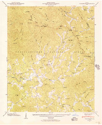 1946 Tickanetley1956 Print · USGSGilmer and Fannin counties in the mid-1940s reveal a landscape of mountain settlements and high-altitude lookouts. Genealogists can trace family roots through Scrougetown Cem, New Liberty Ch, and schools like Twiggs Sch or Salem Sch.2 unique versions available
 - 1947 Map of Tickanetley
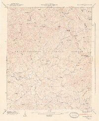 1947 Tickanetley1947 Print · USGSNorth Georgia’s high ridges and mountain hollows are captured here just after the war, showing a landscape of small schools and isolated churches. Genealogists can trace family roots through landmarks like Mathis Chapel School, the Pisgah (PO), and Stanley Mill.2 unique versions available
End of results
Showing maps 1-2 of 2
Top cities near Roy
- Jasper historical maps
- Ellijay historical maps
- Dawsonville historical maps
- Blue Ridge historical maps
- East Ellijay historical maps
- Morganton historical maps
See more
Frequently asked questions
- What are the different types of historical maps available for Roy?
- What is the oldest map of Roy?
- Where can I purchase historical maps of Roy for my home or office?
- Where can I download high-res historical maps of Roy?
- Are there historical topographic maps available for Roy?
- Is there historical aerial imagery available for Roy?
- Where are historical maps of Roy sourced from?