1970s Maps of Edge Hill, Georgia
Explore 2 historic maps of Edge Hill from the 1970s. These maps offer a rare glimpse into what life looked like during the 1970s — showing old roads, neighborhoods, homes, and landmarks that have changed or disappeared over time.
Whether you're researching your family's past, planning a metal detecting trip, or studying how Edge Hill's landscape evolved across the 1970s, these high-resolution maps are a powerful tool for exploring the history of this region.
- Focus on a specific era: All maps on this page are from the 1970s, giving you a focused view of this time period.
- See what’s changed: Compare century-old streets, trails, and buildings to today's modern landscape using overlays and satellite layers.
- Research with precision: Use these maps for genealogy, historical research, land use analysis, or educational projects.
- View, download, or print: Maps are fully viewable online in high resolution, and can be downloaded or printed for your own records.
Start exploring Edge Hill's history through authentic maps from the 1970s. This is your window into the past.
Edge Hill, GA maps
(2)- 1972 Map of Gibson, 1974 Print
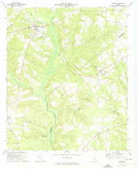 1972 Gibson1974 Print · USGSGlascock County is captured here in the early seventies, centered on the historic town of Gibson and the neighboring community of Avera. Researchers can trace old family sites and transport routes, including the Old Railroad Grade, Glovers Millpond, and Jordan Chapel.
 - 1972 Map of Mitchell, 1975 Print
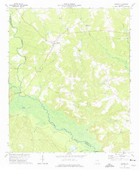 1972 Mitchell1975 Print · USGSGlascock County is documented in the early seventies, showing a rural landscape defined by the winding Ogeechee River and its creeks. Researchers can locate family landmarks such as Friendship Ch, Kents Millpond, and the settlement of Agricola.
End of results
Showing maps 1-2 of 2
Top cities near Edge Hill
- Sandersville historical maps
- Louisville historical maps
- Wrens historical maps
- Tennille historical maps
- Davisboro historical maps
- Gibson historical maps
See more
Top neighborhoods of Edge Hill
Frequently asked questions
- What are the different types of historical maps available for Edge Hill?
- What is the oldest map of Edge Hill?
- Where can I purchase historical maps of Edge Hill for my home or office?
- Where can I download high-res historical maps of Edge Hill?
- Are there historical topographic maps available for Edge Hill?
- Is there historical aerial imagery available for Edge Hill?
- Where are historical maps of Edge Hill sourced from?