1970s Maps of Swaggy Valley, Georgia
Explore 1 historic maps of Swaggy Valley from the 1970s. These maps offer a rare glimpse into what life looked like during the 1970s — showing old roads, neighborhoods, homes, and landmarks that have changed or disappeared over time.
Whether you're researching your family's past, planning a metal detecting trip, or studying how Swaggy Valley's landscape evolved across the 1970s, these high-resolution maps are a powerful tool for exploring the history of this region.
- Focus on a specific era: All maps on this page are from the 1970s, giving you a focused view of this time period.
- See what’s changed: Compare century-old streets, trails, and buildings to today's modern landscape using overlays and satellite layers.
- Research with precision: Use these maps for genealogy, historical research, land use analysis, or educational projects.
- View, download, or print: Maps are fully viewable online in high resolution, and can be downloaded or printed for your own records.
Start exploring Swaggy Valley's history through authentic maps from the 1970s. This is your window into the past.
Swaggy Valley, GA maps
(1)- 1972 Map of White Plains, 1975 Print
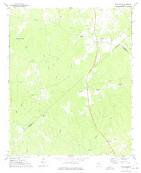 1972 White Plains1975 Print · USGSThe Georgia countryside at the junction of Greene, Hancock, and Taliaferro Counties is captured here in the early seventies. Genealogists can locate family landmarks such as Pierce Chapel, Mosquito Crossing, and Centennial Ch among the many creeks and hollows.2 unique versions available
End of results
Showing maps 1-1 of 1
Top cities near Swaggy Valley
- Greensboro historical maps
- Union Point historical maps
- Sparta historical maps
- Crawfordville historical maps
- Crooked Creek historical maps
- Woodville historical maps
See more
Frequently asked questions
- What are the different types of historical maps available for Swaggy Valley?
- What is the oldest map of Swaggy Valley?
- Where can I purchase historical maps of Swaggy Valley for my home or office?
- Where can I download high-res historical maps of Swaggy Valley?
- Are there historical topographic maps available for Swaggy Valley?
- Is there historical aerial imagery available for Swaggy Valley?
- Where are historical maps of Swaggy Valley sourced from?