1960s Maps of Union Point, Georgia
Explore 3 historic maps of Union Point from the 1960s. These maps offer a rare glimpse into what life looked like during the 1960s — showing old roads, neighborhoods, homes, and landmarks that have changed or disappeared over time.
Whether you're researching your family's past, planning a metal detecting trip, or studying how Union Point's landscape evolved across the 1960s, these high-resolution maps are a powerful tool for exploring the history of this region.
- Focus on a specific era: All maps on this page are from the 1960s, giving you a focused view of this time period.
- See what’s changed: Compare century-old streets, trails, and buildings to today's modern landscape using overlays and satellite layers.
- Research with precision: Use these maps for genealogy, historical research, land use analysis, or educational projects.
- View, download, or print: Maps are fully viewable online in high resolution, and can be downloaded or printed for your own records.
Start exploring Union Point's history through authentic maps from the 1960s. This is your window into the past.
Union Point, GA maps
(3)- 1963 Map of Athens
 1963 Athens1963 Print · USGSGeorgia's Piedmont and the Savannah River valley are captured in the early sixties as major reservoirs and military installations reshaped the landscape. Researchers can trace the development of Clark Hill Reservoir, locate the Fort Gordon Military Reservation, and find historic towns like Social Circle and Eatonton.
 - 1965 Map of Woodville, 1966 Print
 1965 Woodville1966 Print · USGSGreene and Oglethorpe counties are mapped in the mid-sixties, showing a landscape of rural hamlets and river forks. Researchers can trace family history through sites like Bairdstown, Durham Town, and the Bethesda Ch cemetery.2 unique versions available
 - 1965 Map of Union Point, 1966 Print
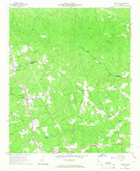
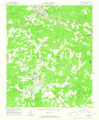 1965 Union Point1966 Print · USGSUnion Point and Siloam are captured during the mid-sixties as vital rural hubs in Greene County. Researchers can trace local heritage through landmarks like the Wesleyan Campground, Jefferson Hall, and the Buffalo Lick Monument.3 unique versions available
End of results
Showing maps 1-3 of 3
Top cities near Union Point
- Greensboro historical maps
- Crawfordville historical maps
- Woodville historical maps
- White Plains historical maps
- Siloam historical maps
- Maxeys historical maps
See more
Frequently asked questions
- What are the different types of historical maps available for Union Point?
- What is the oldest map of Union Point?
- Where can I purchase historical maps of Union Point for my home or office?
- Where can I download high-res historical maps of Union Point?
- Are there historical topographic maps available for Union Point?
- Is there historical aerial imagery available for Union Point?
- Where are historical maps of Union Point sourced from?