1990s Maps of Mountain Brooke, Gwinnett County
Explore 2 historic maps of Mountain Brooke from the 1990s. These maps offer a rare glimpse into what life looked like during the 1990s — showing old roads, neighborhoods, homes, and landmarks that have changed or disappeared over time.
Whether you're researching your family's past, planning a metal detecting trip, or studying how Mountain Brooke's landscape evolved across the 1990s, these high-resolution maps are a powerful tool for exploring the history of this region.
- Focus on a specific era: All maps on this page are from the 1990s, giving you a focused view of this time period.
- See what’s changed: Compare century-old streets, trails, and buildings to today's modern landscape using overlays and satellite layers.
- Research with precision: Use these maps for genealogy, historical research, land use analysis, or educational projects.
- View, download, or print: Maps are fully viewable online in high resolution, and can be downloaded or printed for your own records.
Start exploring Mountain Brooke's history through authentic maps from the 1990s. This is your window into the past.
Mountain Brooke, Gwinnett County maps
(2)- 1992 Map of Stone Mountain
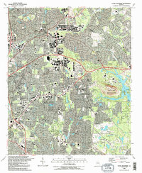 1992 Stone Mountain1992 Print · USGSDeKalb County enters a period of intense suburban growth in the early nineties, centered around the iconic granite mass of Stone Mountain. Genealogists and local historians can trace community roots through numerous landmarks like Rehoboth Cem, Zion Ch, and the Atlanta Sch for the Deaf.2 unique versions available
 - 1997 Map of Stone Mountain, 1999 Print
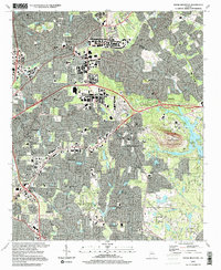 1997 Stone Mountain1999 Print · USGSDeKalb and Gwinnett counties show a mature suburban landscape in the late nineties, centered on the unmistakable profile of Stone Mountain. Genealogists and local historians can trace established communities like Tucker and Clarkston, locating numerous neighborhood landmarks such as Rehoboth Ch and Stone Mountain Cem.
End of results
Showing maps 1-2 of 2
Frequently asked questions
- What are the different types of historical maps available for Mountain Brooke?
- What is the oldest map of Mountain Brooke?
- Where can I purchase historical maps of Mountain Brooke for my home or office?
- Where can I download high-res historical maps of Mountain Brooke?
- Are there historical topographic maps available for Mountain Brooke?
- Is there historical aerial imagery available for Mountain Brooke?
- Where are historical maps of Mountain Brooke sourced from?