1900s (20th Century) Maps of Locust Grove, Georgia
Explore 8 historic maps of Locust Grove from the 1900s (20th Century). These maps offer a rare glimpse into what life looked like during the 1900s — showing old roads, neighborhoods, homes, and landmarks that have changed or disappeared over time.
Whether you're researching your family's past, planning a metal detecting trip, or studying how Locust Grove's landscape evolved across the 1900s, these high-resolution maps are a powerful tool for exploring the history of this region.
- Focus on a specific era: All maps on this page are from the 1900s, giving you a focused view of this time period.
- See what’s changed: Compare century-old streets, trails, and buildings to today's modern landscape using overlays and satellite layers.
- Research with precision: Use these maps for genealogy, historical research, land use analysis, or educational projects.
- View, download, or print: Maps are fully viewable online in high resolution, and can be downloaded or printed for your own records.
Start exploring Locust Grove's history through authentic maps from the 1900s. This is your window into the past.
Locust Grove, GA maps
(8)- 1953 Map of Atlanta, 1965 Print
 1953 Atlanta1965 Print · USGSThe growing Atlanta metro and the industrial corridors of Eastern Alabama are captured here during the mid-century transition. Researchers can trace the rail-to-road shift through hubs like Anniston and La Grange or locate sites within Fort McClellan.2 unique versions available
 - 1957 Map of Atlanta
 1957 Atlanta1957 Print · USGSAtlanta and the Alabama borderlands appear here in the mid-fifties, capturing the region's post-war suburban and industrial transition. Trace the development of early transport hubs and military sites like Fort McPherson, Anniston, and the Kennesaw Mountain National Battlefield Park.
 - 1958 Map of Atlanta
 1958 Atlanta1958 Print · USGSMid-century Georgia and Alabama are shown in this regional study of the corridor between the Chattahoochee River and the Appalachian foothills. Local historians can trace the development of suburban Atlanta alongside vital landmarks like Stone Mountain, Dobbins AFB, and the Seaboard Air Line rail routes.
 - 1964 Map of Luella, 1965 Print
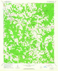
 1964 Luella1965 Print · USGSHenry and Spalding Counties are captured here in the mid-sixties, showing a rural landscape anchored by the Southern railroad. Genealogists can locate family landmarks like Pullin Cem, Steeles Mill, and Hosanna Ch near the settlement of Luella.3 unique versions available
 - 1964 Map of Mc Donough, 1965 Print
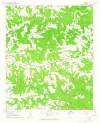
 1964 Mc Donough1965 Print · USGSHenry County in the mid-1960s was a landscape of deep-rooted rural communities tied together by the Southern railroad and country churches. Genealogists and local historians can trace family locations through markers like Cleveland Cem, Turner Church, and the Shingle Roof Campground.4 unique versions available
 - 1964 Map of Ola, 1965 Print
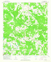
 1964 Ola1965 Print · USGSHenry County remains a pastoral landscape of family farms and creek-side settlements in the mid-1960s. Genealogists can trace family roots through numerous sites like Old Mt Bethel Cem, Humphrey Cem, and the community hub at Ola.3 unique versions available
 - 1964 Map of Locust Grove, 1965 Print
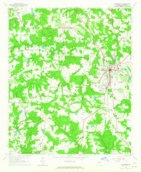
 1964 Locust Grove1965 Print · USGSThe Piedmont landscape of Henry and Butts Counties is shown during the mid-sixties, centered on the railroad towns of Locust Grove and Jenkinsburg. Genealogists can trace family names at the Beersheba Cem or locate rural meeting places like England Chapel.3 unique versions available
 - 1979 Map of Griffin, 1980 Print
 1979 Griffin1980 Print · USGSWest-central Georgia at the close of the seventies reveals a landscape of historic rail towns and growing suburbs between the major river systems. Trace the rail lines and early road networks connecting Griffin, Peachtree City, and Newnan, or locate smaller settlements like Senoia and Experiment.3 unique versions available
End of results
Showing maps 1-8 of 8
Top cities near Locust Grove
- Stockbridge historical maps
- McDonough historical maps
- Griffin historical maps
- Covington historical maps
- Hampton historical maps
- Morrow historical maps
See more
Top neighborhoods of Locust Grove
Frequently asked questions
- What are the different types of historical maps available for Locust Grove?
- What is the oldest map of Locust Grove?
- Where can I purchase historical maps of Locust Grove for my home or office?
- Where can I download high-res historical maps of Locust Grove?
- Are there historical topographic maps available for Locust Grove?
- Is there historical aerial imagery available for Locust Grove?
- Where are historical maps of Locust Grove sourced from?