1990s Maps of Jackson County, Georgia
Explore 3 historic maps of Jackson County from the 1990s. These maps offer a rare glimpse into what life looked like during the 1990s — showing old roads, neighborhoods, homes, and landmarks that have changed or disappeared over time.
Whether you're researching your family's past, planning a metal detecting trip, or studying how Jackson County's landscape evolved across the 1990s, these high-resolution maps are a powerful tool for exploring the history of this region.
- Focus on a specific era: All maps on this page are from the 1990s, giving you a focused view of this time period.
- See what’s changed: Compare century-old streets, trails, and buildings to today's modern landscape using overlays and satellite layers.
- Research with precision: Use these maps for genealogy, historical research, land use analysis, or educational projects.
- View, download, or print: Maps are fully viewable online in high resolution, and can be downloaded or printed for your own records.
Start exploring Jackson County's history through authentic maps from the 1990s. This is your window into the past.
Jackson County, GA maps
(3)- 1992 Map of Chestnut Mountain, 1993 Print
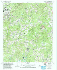 1992 Chestnut Mountain1993 Print · USGSHall County and Jackson County meet in the early nineties as educational centers and motorsports venues began to reshape this Georgia landscape. Genealogists and historians can trace family ties through Tanner Mill, Hopewell Cem, and Cross Plains Cem.
 - 1993 Map of Auburn
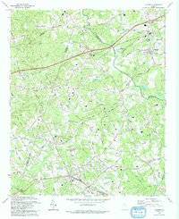 1993 Auburn1993 Print · USGSBarrow and Gwinnett counties were undergoing steady growth in the early nineties, centered on the Seaboard System rail towns. Genealogists can trace family names through numerous rural landmarks like Thompsons Mill, Hebron Cem, and Harmony Grove Ch.
 - 1998 Map of Athens West, 1999 Print
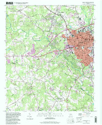 1998 Athens West1999 Print · USGSIn the late nineties, the western outskirts of Athens and Watkinsville showcase a landscape where academic and naval facilities meet traditional Georgia riverlands. Researchers can trace the Georgia Railroad and locate local landmarks like the Athens Speedway or Chestnut Grove Ch.
End of results
Showing maps 1-3 of 3
Top cities of Jackson County
- Jefferson historical maps
- Commerce historical maps
- Arcade historical maps
- Nicholson historical maps
- Hoschton historical maps
- Pendergrass historical maps
See more
Frequently asked questions
- What are the different types of historical maps available for Jackson County?
- What is the oldest map of Jackson County?
- Where can I purchase historical maps of Jackson County for my home or office?
- Where can I download high-res historical maps of Jackson County?
- Are there historical topographic maps available for Jackson County?
- Is there historical aerial imagery available for Jackson County?
- Where are historical maps of Jackson County sourced from?