Old Maps of Burnt Hickory Ridge Estates, Paulding County for Hiking & Exploration
Hike through history with 11 historic maps of Burnt Hickory Ridge Estates. Explore old trails, ghost towns, and forgotten backroads — perfect for outdoor adventurers and local explorers.
- Rediscover forgotten places: Map out old mining camps, roads, and footpaths that no longer exist on modern maps.
- Layer with modern tools: Combine with LiDAR or satellite views to plan hikes through historical terrain.
- Made for exploration: Popular among hikers, overlanders, and local history lovers.
Use these maps to find adventure and explore the hidden past of Burnt Hickory Ridge Estates.
Burnt Hickory Ridge Estates, Paulding County maps
(11)- 1890 Map of Cartersville
 1890 Cartersville1890 Print · USGSCovers Burnt Hickory Ridge Estates, including Marietta, Kennesaw, and other nearby areas
 - 1891 Map of Cartersville
 1891 Cartersville1891 Print · USGSCovers Burnt Hickory Ridge Estates, including Marietta, Kennesaw, and other nearby areas
 - 1896 Map of Cartersville
 1896 Cartersville1896 Print · USGSCovers Burnt Hickory Ridge Estates, including Marietta, Kennesaw, and other nearby areas4 unique versions available
 - 1906 Map of Stilesboro, 1971 Print
 1906 Stilesboro1971 Print · USGSCovers Burnt Hickory Ridge Estates, including Cartersville, Euharlee, and other nearby areas
 - 1908 Map of Stilesboro
 1908 Stilesboro1908 Print · USGSCovers Burnt Hickory Ridge Estates, including Cartersville, Euharlee, and other nearby areas
 - 1955 Map of Rome
 1955 Rome1955 Print · USGSCovers Burnt Hickory Ridge Estates, including Chattanooga, Sandy Springs, and other nearby areas
 - 1958 Map of Rome, 1966 Print
 1958 Rome1966 Print · USGSCovers Burnt Hickory Ridge Estates, including Chattanooga, Sandy Springs, and other nearby areas3 unique versions available
 - 1961 Map of Rome
 1961 Rome1961 Print · USGSCovers Burnt Hickory Ridge Estates, including Chattanooga, Sandy Springs, and other nearby areas
 - 1963 Map of Rome
 1963 Rome1963 Print · USGSCovers Burnt Hickory Ridge Estates, including Chattanooga, Sandy Springs, and other nearby areas
 - 1972 Map of Burnt Hickory Ridge, 1974 Print
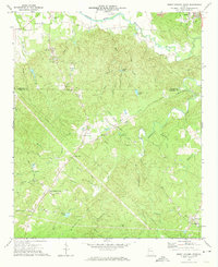 1972 Burnt Hickory Ridge1974 Print · USGSCovers Burnt Hickory Ridge Estates, including Cartersville, Emerson, and other nearby areas2 unique versions available
 - 1981 Map of Cartersville, 1982 Print
 1981 Cartersville1982 Print · USGSCovers Burnt Hickory Ridge Estates, including Sandy Springs, Roswell, and other nearby areas2 unique versions available
End of results
Showing maps 1-11 of 11
Frequently asked questions
- What are the different types of historical maps available for Burnt Hickory Ridge Estates?
- What is the oldest map of Burnt Hickory Ridge Estates?
- Where can I purchase historical maps of Burnt Hickory Ridge Estates for my home or office?
- Where can I download high-res historical maps of Burnt Hickory Ridge Estates?
- Are there historical topographic maps available for Burnt Hickory Ridge Estates?
- Is there historical aerial imagery available for Burnt Hickory Ridge Estates?
- Where are historical maps of Burnt Hickory Ridge Estates sourced from?