1970s Maps of Hiram, Georgia
Explore 2 historic maps of Hiram from the 1970s. These maps offer a rare glimpse into what life looked like during the 1970s — showing old roads, neighborhoods, homes, and landmarks that have changed or disappeared over time.
Whether you're researching your family's past, planning a metal detecting trip, or studying how Hiram's landscape evolved across the 1970s, these high-resolution maps are a powerful tool for exploring the history of this region.
- Focus on a specific era: All maps on this page are from the 1970s, giving you a focused view of this time period.
- See what’s changed: Compare century-old streets, trails, and buildings to today's modern landscape using overlays and satellite layers.
- Research with precision: Use these maps for genealogy, historical research, land use analysis, or educational projects.
- View, download, or print: Maps are fully viewable online in high resolution, and can be downloaded or printed for your own records.
Start exploring Hiram's history through authentic maps from the 1970s. This is your window into the past.
Hiram, GA maps
(2)- 1973 Map of Dallas, 1975 Print
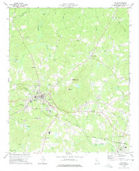 1973 Dallas1975 Print · USGSPaulding County thrived in the early seventies as a rail-and-river hub centered on the community of Dallas. Genealogists and historians can trace the foundations of local life through dozens of landmarks like Shady Grove Ch, Matthews Sch, and the Drive-in Theater.3 unique versions available
 - 1973 Map of Nebo, 1975 Print
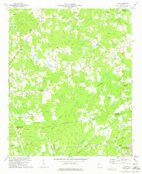 1973 Nebo1975 Print · USGSPaulding and Douglas Counties are captured here in the early 1970s, showing a rural landscape before the rapid expansion of the Atlanta metro area. Genealogists and local historians can locate several country churches and settlements, including Sudie, Brownsville, and the Callie Harbin Ch.3 unique versions available
End of results
Showing maps 1-2 of 2
Top cities near Hiram
- Marietta historical maps
- Smyrna historical maps
- Mableton historical maps
- Kennesaw historical maps
- Douglasville historical maps
- Woodstock historical maps
See more
Top neighborhoods of Hiram
- Nebo historical maps
- Devonshire historical maps
- Echo Ridge historical maps
- Indian Lake historical maps
- Country Club Estates historical maps
- The South Forty historical maps
See more
Frequently asked questions
- What are the different types of historical maps available for Hiram?
- What is the oldest map of Hiram?
- Where can I purchase historical maps of Hiram for my home or office?
- Where can I download high-res historical maps of Hiram?
- Are there historical topographic maps available for Hiram?
- Is there historical aerial imagery available for Hiram?
- Where are historical maps of Hiram sourced from?