1970s Maps of Merrillville, Georgia
Explore 3 historic maps of Merrillville from the 1970s. These maps offer a rare glimpse into what life looked like during the 1970s — showing old roads, neighborhoods, homes, and landmarks that have changed or disappeared over time.
Whether you're researching your family's past, planning a metal detecting trip, or studying how Merrillville's landscape evolved across the 1970s, these high-resolution maps are a powerful tool for exploring the history of this region.
- Focus on a specific era: All maps on this page are from the 1970s, giving you a focused view of this time period.
- See what’s changed: Compare century-old streets, trails, and buildings to today's modern landscape using overlays and satellite layers.
- Research with precision: Use these maps for genealogy, historical research, land use analysis, or educational projects.
- View, download, or print: Maps are fully viewable online in high resolution, and can be downloaded or printed for your own records.
Start exploring Merrillville's history through authentic maps from the 1970s. This is your window into the past.
Merrillville, GA maps
(3)- 1975 Map of Merrillville, 1986 Print
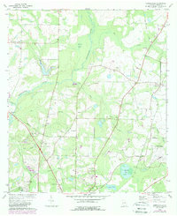 1975 Merrillville1986 Print · USGSNortheast of Thomasville in the 1970s, this Thomas County landscape is defined by the winding Ochlocknee River and its rural outposts. Genealogists can trace family connections through numerous landmarks like Spring Hill Ch, Wilson Cem, and the settlement of Merrillville.
 - 1977 Map of Patten
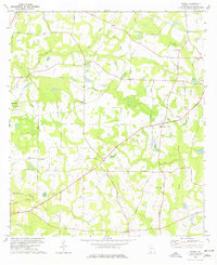 1977 Patten1977 Print · USGSThomas County in the late seventies is a landscape of established rural communities and scattered family homesteads. Researchers can trace local heritage through numerous landmarks like Patten, Mt Calvary Ch Cem, and the Aucilla River.
 - 1978 Map of Merrillville
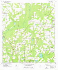 1978 Merrillville1978 Print · USGSThomas County in the late 1970s reveals a rural landscape defined by the winding Ochlockonee River and the busy Seaboard Coast Line railroad. Genealogists can locate numerous landmarks including Wilson Cem, Beulah Hill Ch, and the historic Confederate Bridge.
End of results
Showing maps 1-3 of 3
Top cities near Merrillville
- Thomasville historical maps
- Moultrie historical maps
- Boston historical maps
- Meigs historical maps
- Ochlocknee historical maps
- Coolidge historical maps
Frequently asked questions
- What are the different types of historical maps available for Merrillville?
- What is the oldest map of Merrillville?
- Where can I purchase historical maps of Merrillville for my home or office?
- Where can I download high-res historical maps of Merrillville?
- Are there historical topographic maps available for Merrillville?
- Is there historical aerial imagery available for Merrillville?
- Where are historical maps of Merrillville sourced from?