1940s Maps of Presley, Georgia
Explore 2 historic maps of Presley from the 1940s. These maps offer a rare glimpse into what life looked like during the 1940s — showing old roads, neighborhoods, homes, and landmarks that have changed or disappeared over time.
Whether you're researching your family's past, planning a metal detecting trip, or studying how Presley's landscape evolved across the 1940s, these high-resolution maps are a powerful tool for exploring the history of this region.
- Focus on a specific era: All maps on this page are from the 1940s, giving you a focused view of this time period.
- See what’s changed: Compare century-old streets, trails, and buildings to today's modern landscape using overlays and satellite layers.
- Research with precision: Use these maps for genealogy, historical research, land use analysis, or educational projects.
- View, download, or print: Maps are fully viewable online in high resolution, and can be downloaded or printed for your own records.
Start exploring Presley's history through authentic maps from the 1940s. This is your window into the past.
Presley, GA maps
(2)- 1941 Map of Osborn
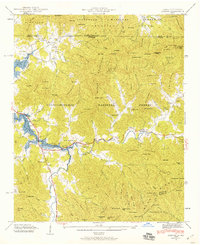 1941 Osborn1941 Print · USGSTowns County, Georgia, and Clay County, North Carolina, appear here during the creation of the Hiwassee River reservoir system. Genealogists and hikers can trace the Appalachian Trail through the mountains or find local landmarks like Osborn, Ivy Mount Cem, and Lower Hightower Sch.2 unique versions available
 - 1943 Map of Osborn
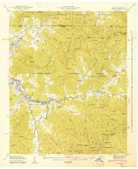 1943 Osborn1943 Print · USGSTowns County, Georgia, and Clay County, North Carolina, appear here during the early years of the Chatuge Reservoir. Genealogists can locate family landmarks like Garrett Cem, Upper Bell Sch, and the small settlement of Osborn along Hightower Creek.
End of results
Showing maps 1-2 of 2
Top cities near Presley
- Hiawassee historical maps
- Blairsville historical maps
- Helen historical maps
- Young Harris historical maps
- Hayesville historical maps
Frequently asked questions
- What are the different types of historical maps available for Presley?
- What is the oldest map of Presley?
- Where can I purchase historical maps of Presley for my home or office?
- Where can I download high-res historical maps of Presley?
- Are there historical topographic maps available for Presley?
- Is there historical aerial imagery available for Presley?
- Where are historical maps of Presley sourced from?