1970s Maps of Thomaston, Georgia
Explore 2 historic maps of Thomaston from the 1970s. These maps offer a rare glimpse into what life looked like during the 1970s — showing old roads, neighborhoods, homes, and landmarks that have changed or disappeared over time.
Whether you're researching your family's past, planning a metal detecting trip, or studying how Thomaston's landscape evolved across the 1970s, these high-resolution maps are a powerful tool for exploring the history of this region.
- Focus on a specific era: All maps on this page are from the 1970s, giving you a focused view of this time period.
- See what’s changed: Compare century-old streets, trails, and buildings to today's modern landscape using overlays and satellite layers.
- Research with precision: Use these maps for genealogy, historical research, land use analysis, or educational projects.
- View, download, or print: Maps are fully viewable online in high resolution, and can be downloaded or printed for your own records.
Start exploring Thomaston's history through authentic maps from the 1970s. This is your window into the past.
Thomaston, GA maps
(2)- 1971 Map of Lincoln Park, 1973 Print
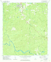 1971 Lincoln Park1973 Print · USGSUpson County at the start of the 1970s reveals a landscape of rural crossroads and river shoals just south of Thomaston. Researchers can trace family history through sites like Southview Cem, the Mica Pit, and local landmarks such as Snipes Grave Rock and Zion Chapel.2 unique versions available
 - 1971 Map of Thomaston, 1973 Print
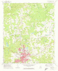 1971 Thomaston1973 Print · USGSThomaston and its textile-mill suburbs of Silvertown and East Thomaston are captured here in the early seventies during a period of steady regional growth. Family researchers can locate Glenwood Cem, Shady Grove Ch, and the site of Hannahs Mill along the surrounding creek branches.2 unique versions available
End of results
Showing maps 1-2 of 2
Top cities near Thomaston
- Barnesville historical maps
- Hannahs Mill historical maps
- Zebulon historical maps
- Sunset Village historical maps
- Talbotton historical maps
- Milner historical maps
See more
Top neighborhoods of Thomaston
Frequently asked questions
- What are the different types of historical maps available for Thomaston?
- What is the oldest map of Thomaston?
- Where can I purchase historical maps of Thomaston for my home or office?
- Where can I download high-res historical maps of Thomaston?
- Are there historical topographic maps available for Thomaston?
- Is there historical aerial imagery available for Thomaston?
- Where are historical maps of Thomaston sourced from?