1960s Maps of Brook Springs, Georgia
Explore 2 historic maps of Brook Springs from the 1960s. These maps offer a rare glimpse into what life looked like during the 1960s — showing old roads, neighborhoods, homes, and landmarks that have changed or disappeared over time.
Whether you're researching your family's past, planning a metal detecting trip, or studying how Brook Springs's landscape evolved across the 1960s, these high-resolution maps are a powerful tool for exploring the history of this region.
- Focus on a specific era: All maps on this page are from the 1960s, giving you a focused view of this time period.
- See what’s changed: Compare century-old streets, trails, and buildings to today's modern landscape using overlays and satellite layers.
- Research with precision: Use these maps for genealogy, historical research, land use analysis, or educational projects.
- View, download, or print: Maps are fully viewable online in high resolution, and can be downloaded or printed for your own records.
Start exploring Brook Springs's history through authentic maps from the 1960s. This is your window into the past.
Brook Springs, GA maps
(2)- 1962 Map of Tabernacle, 1963 Print
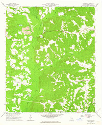 1962 Tabernacle1963 Print · USGSWashington County at the start of the 1960s reveals a rural landscape of scattered churches and mining operations among the tributaries of Buffalo Creek. Researchers can trace the CENTRAL OF GEORGIA rail line or locate family sites like Ruthford Cem and Jordan Station Ch.2 unique versions available
 - 1964 Map of Macon
 1964 Macon1964 Print · USGSCentral Georgia in the mid-sixties is defined by its major river valleys and a booming military presence. Genealogists and historians can trace the growth of Warner Robins near Robins AFB or locate smaller rural junctions like Allentown and Jeffersonville along the historic Southern railroad lines.2 unique versions available
End of results
Showing maps 1-2 of 2
Top cities near Brook Springs
- Sandersville historical maps
- Wrightsville historical maps
- Tennille historical maps
- Irwinton historical maps
- Harrison historical maps
- Toomsboro historical maps
See more
Frequently asked questions
- What are the different types of historical maps available for Brook Springs?
- What is the oldest map of Brook Springs?
- Where can I purchase historical maps of Brook Springs for my home or office?
- Where can I download high-res historical maps of Brook Springs?
- Are there historical topographic maps available for Brook Springs?
- Is there historical aerial imagery available for Brook Springs?
- Where are historical maps of Brook Springs sourced from?