1940s Maps of Whitfield County, Georgia
Explore 9 historic maps of Whitfield County from the 1940s. These maps offer a rare glimpse into what life looked like during the 1940s — showing old roads, neighborhoods, homes, and landmarks that have changed or disappeared over time.
Whether you're researching your family's past, planning a metal detecting trip, or studying how Whitfield County's landscape evolved across the 1940s, these high-resolution maps are a powerful tool for exploring the history of this region.
- Focus on a specific era: All maps on this page are from the 1940s, giving you a focused view of this time period.
- See what’s changed: Compare century-old streets, trails, and buildings to today's modern landscape using overlays and satellite layers.
- Research with precision: Use these maps for genealogy, historical research, land use analysis, or educational projects.
- View, download, or print: Maps are fully viewable online in high resolution, and can be downloaded or printed for your own records.
Start exploring Whitfield County's history through authentic maps from the 1940s. This is your window into the past.
Whitfield County, GA maps
(9)- 1943 Map of Dalton
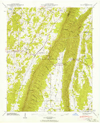
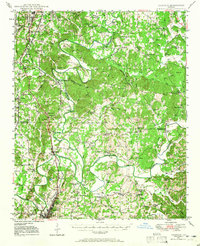
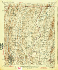 1943 Dalton1943 Print · USGSWhitfield and Murray counties come alive in the 1940s, showing the early industrial growth of the carpet capital and the surrounding farming settlements. Researchers can locate family landmarks like Praters Mill, Gregorys Mill, and the many rural sites such as Shiloh Ch or Oak Grove Sch.2 unique versions available
 - 1943 Map of Tunnel Hill, 1946 Print
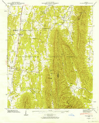
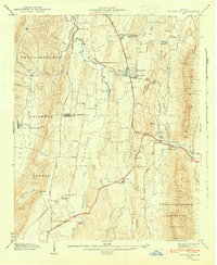 1943 Tunnel Hill1946 Print · USGSWhitfield and Catoosa Counties are shown here during the mid-1940s, a period when mountain ridges still dictated the flow of commerce and travel. Genealogists and historians can locate numerous small churches and family landmarks like New Hope Ch, Callaway Mill, and the Chattanooga and Nashville Railroad tunnel.5 unique versions available
 - 1946 Map of Ringgold, 1947 Print
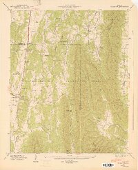
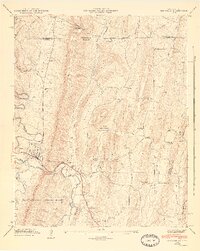 1946 Ringgold1947 Print · USGSCatoosa County is captured here just after the war, showing the industrial and agricultural landscape surrounding Ringgold. Genealogists can trace family sites like the Anderson Cem, Union Academy, and Cherokee Valley Church.5 unique versions available
 - 1946 Map of Nickajack Gap, 1947 Print
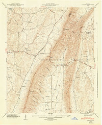
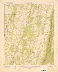 1946 Nickajack Gap1947 Print · USGSNorth Georgia’s ridge-and-valley corridor is captured here in the mid-1940s, showing a landscape of railway junctions and rural farmsteads. Genealogists can trace family connections through sites like Yates Cem, Rock Spring Sch, and the community of Wood Station.5 unique versions available
 - 1946 Map of Catlett, 1962 Print
 1946 Catlett1962 Print · USGSWalker County, Georgia, at the end of the Second World War was a landscape of remote mountain gaps and tight-knit valley communities. Genealogists and researchers can trace the locations of family landmarks like Whitley Cem, Hickory Hill Sch, and the community at Naomi.2 unique versions available
 - 1946 Map of Villanow, 1964 Print
 1946 Villanow1964 Print · USGSNorthwestern Georgia’s ridges and hollows appear in detail just after the war, showing the rural communities along the Whitfield and Walker County line. Genealogists and hikers can trace old cemeteries and mountain passes, from Villanow and Snake Creek Gap to Redwine Cove Cem.3 unique versions available
 - 1947 Map of Villanow
 1947 Villanow1947 Print · USGSThe Whitfield and Walker County line comes alive in this late 1940s survey of the Georgia uplands. Genealogists can locate family landmarks like Phillips Cem, Redwine Cove Cem, and the historic settlement at Villanow.2 unique versions available
 - 1947 Map of Catlett
 1947 Catlett1947 Print · USGSIn the late 1940s, the rural ridges of Walker County were a world of isolated valleys and steep mountain passes. Genealogists can trace family roots through several churches and schools like Mt Zion Ch, Corinth Sch, and Shiloh Cem.2 unique versions available
 - 1949 Map of Calhoun, 1965 Print
 1949 Calhoun1965 Print · USGSNorthwest Georgia at mid-century reveals a landscape shaped by river confluences and early transportation routes like the Dixie Highway. Researchers can trace ancestral locations near Echota Village, Resaca Confederate Cemetery, and numerous country churches like Smyrna Church.
End of results
Showing maps 1-9 of 9
Top cities of Whitfield County
Frequently asked questions
- What are the different types of historical maps available for Whitfield County?
- What is the oldest map of Whitfield County?
- Where can I purchase historical maps of Whitfield County for my home or office?
- Where can I download high-res historical maps of Whitfield County?
- Are there historical topographic maps available for Whitfield County?
- Is there historical aerial imagery available for Whitfield County?
- Where are historical maps of Whitfield County sourced from?