1980s Maps of Honalo, Hawaii
Explore 5 historic maps of Honalo from the 1980s. These maps offer a rare glimpse into what life looked like during the 1980s — showing old roads, neighborhoods, homes, and landmarks that have changed or disappeared over time.
Whether you're researching your family's past, planning a metal detecting trip, or studying how Honalo's landscape evolved across the 1980s, these high-resolution maps are a powerful tool for exploring the history of this region.
- Focus on a specific era: All maps on this page are from the 1980s, giving you a focused view of this time period.
- See what’s changed: Compare century-old streets, trails, and buildings to today's modern landscape using overlays and satellite layers.
- Research with precision: Use these maps for genealogy, historical research, land use analysis, or educational projects.
- View, download, or print: Maps are fully viewable online in high resolution, and can be downloaded or printed for your own records.
Start exploring Honalo's history through authentic maps from the 1980s. This is your window into the past.
Honalo, HI maps
(5)- 1980 Map of Hawaii County Sheet 1, 1984 Print
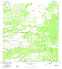
 1980 Hawaii County Sheet 11984 Print · USGSThe Big Island's diverse terrain and transition into the 1980s are shown here, from the northern coast to the high mountain saddles. Genealogists and historians can trace homesteads and local roads near Kailua, Kukuihaele, and the Ahualoa area.
 - 1982 Map of Puu Lehua
 1982 Puu Lehua1982 Print · USGSThe high slopes of the Kona Districts are captured here in the early eighties, showing a landscape shaped by lava flows and high-altitude ranching. Genealogists and historians can trace family sites and land use at Puu Lehua Ranch, the Kahelepo House (Site), and the rugged Devil Country.2 unique versions available
 - 1982 Map of Kealakekua
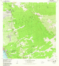
 1982 Kealakekua1982 Print · USGSThe Kona coast of Hawaii Island in the early eighties reveals a unique mix of ancient Hawaiian sites and modern mountain communities. Trace historic land divisions and find landmarks like the Kamehameha Birthplace, Konawaena High School, and Kona Hospital.2 unique versions available
 - 1982 Map of Hualalai
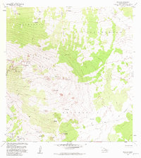 1982 Hualalai1982 Print · USGSHigh on the slopes of North Kona during the early eighties, this survey captures a landscape defined by volcanic history and ancient sites. Genealogists and historians can trace the Judd Trail and locate the historic Ahu a Umi Heiau and Hale Pili among the cinder cones.2 unique versions available
 - 1982 Map of Kailua, 1983 Print
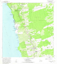
 1982 Kailua1983 Print · USGSThe Kona coast in the early eighties shows the expansion of Kailua and its surrounding homesteads into the upland forests. Researchers can trace land divisions from Kailua-Kona PO to rural landmarks like Palani Junction and Honokohau School.
End of results
Showing maps 1-5 of 5
Top neighborhoods of Honalo
Frequently asked questions
- What are the different types of historical maps available for Honalo?
- What is the oldest map of Honalo?
- Where can I purchase historical maps of Honalo for my home or office?
- Where can I download high-res historical maps of Honalo?
- Are there historical topographic maps available for Honalo?
- Is there historical aerial imagery available for Honalo?
- Where are historical maps of Honalo sourced from?