1950s Maps of Kailua, Hawaii
Explore 5 historic maps of Kailua from the 1950s. These maps offer a rare glimpse into what life looked like during the 1950s — showing old roads, neighborhoods, homes, and landmarks that have changed or disappeared over time.
Whether you're researching your family's past, planning a metal detecting trip, or studying how Kailua's landscape evolved across the 1950s, these high-resolution maps are a powerful tool for exploring the history of this region.
- Focus on a specific era: All maps on this page are from the 1950s, giving you a focused view of this time period.
- See what’s changed: Compare century-old streets, trails, and buildings to today's modern landscape using overlays and satellite layers.
- Research with precision: Use these maps for genealogy, historical research, land use analysis, or educational projects.
- View, download, or print: Maps are fully viewable online in high resolution, and can be downloaded or printed for your own records.
Start exploring Kailua's history through authentic maps from the 1950s. This is your window into the past.
Kailua, HI maps
(5)- 1954 Map of Hawaii North
 1954 Hawaii North1954 Print · USGSThe Big Island in the mid-fifties shows a landscape of active volcanic history and a peak sugar-mill economy. Trace the route of the Hawaii Consolidated Railway, locate the Olaa Plantation Mill, and see the extent of the Lava flow of 1881 near Hilo.
 - 1959 Map of Hawaii North
 1959 Hawaii North1959 Print · USGSThe northern half of Hawaii Island in the late fifties shows a landscape shaped by historic volcanic activity and a thriving sugar and ranching economy. Researchers can trace historic lava flows alongside local landmarks like Upolu Point Airport, Huehue Ranch, and the Pacific Sugar Mill.
 - 1959 Map of Hualalai, 1960 Print
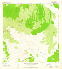 1959 Hualalai1960 Print · USGSNorth Kona's volcanic slopes are captured here in the late fifties, showing the interplay between historic land divisions and the island's terrain. Researchers can locate remote sites like the Ahu a Umi Heiau, follow the Judd Trail, and trace the massive Lava Flow of 1859.2 unique versions available
 - 1959 Map of Keahole Point, 1960 Print
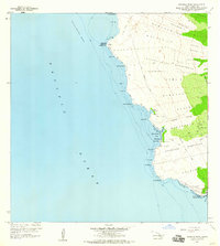 1959 Keahole Point1960 Print · USGSThe North Kona coast in the late fifties is a landscape of volcanic history and sacred sites. Researchers can trace ancestral land divisions like Kalaoa Ooma Homesteads or locate cultural landmarks including Ahuena Heiau and the Kaloko Fishpond.2 unique versions available
 - 1959 Map of Kailua, 1961 Print
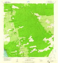 1959 Kailua1961 Print · USGSThe North Kona coast was undergoing significant settlement shifts in the late fifties as homesteads climbed the volcanic slopes. Trace family history and land boundaries through the Kalaoa Homesteads, Honokohau School, and the Holualoa Makai Camp.3 unique versions available
End of results
Showing maps 1-5 of 5
Top neighborhoods of Kailua
- Laniakea historical maps
- Kailua-Kona historical maps
- Malulani Gardens historical maps
- Hillcrest historical maps
- Aloha Kona historical maps
- Aloha Kona historical maps
See more
Frequently asked questions
- What are the different types of historical maps available for Kailua?
- What is the oldest map of Kailua?
- Where can I purchase historical maps of Kailua for my home or office?
- Where can I download high-res historical maps of Kailua?
- Are there historical topographic maps available for Kailua?
- Is there historical aerial imagery available for Kailua?
- Where are historical maps of Kailua sourced from?