1980s Maps of Ka‘ūpūlehu, Hawaiʻi County
Explore 2 historic maps of Ka‘ūpūlehu from the 1980s. These maps offer a rare glimpse into what life looked like during the 1980s — showing old roads, neighborhoods, homes, and landmarks that have changed or disappeared over time.
Whether you're researching your family's past, planning a metal detecting trip, or studying how Ka‘ūpūlehu's landscape evolved across the 1980s, these high-resolution maps are a powerful tool for exploring the history of this region.
- Focus on a specific era: All maps on this page are from the 1980s, giving you a focused view of this time period.
- See what’s changed: Compare century-old streets, trails, and buildings to today's modern landscape using overlays and satellite layers.
- Research with precision: Use these maps for genealogy, historical research, land use analysis, or educational projects.
- View, download, or print: Maps are fully viewable online in high resolution, and can be downloaded or printed for your own records.
Start exploring Ka‘ūpūlehu's history through authentic maps from the 1980s. This is your window into the past.
Ka‘ūpūlehu, Hawaiʻi County maps
(2)- 1980 Map of Hawaii County Sheet 1, 1984 Print
 1980 Hawaii County Sheet 11984 Print · USGSThe Big Island's diverse terrain and transition into the 1980s are shown here, from the northern coast to the high mountain saddles. Genealogists and historians can trace homesteads and local roads near Kailua, Kukuihaele, and the Ahualoa area.
 - 1982 Map of Kiholo
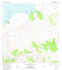 1982 Kiholo1982 Print · USGSThe North Kona coast was defined by recent volcanic history and remote ranching life in the early eighties. Genealogists and historians can trace family lands at Kaulana Homesteads and find landmarks like Akahipuu Cemetery and the Huehue Ranch.2 unique versions available
End of results
Showing maps 1-2 of 2
Frequently asked questions
- What are the different types of historical maps available for Ka‘ūpūlehu?
- What is the oldest map of Ka‘ūpūlehu?
- Where can I purchase historical maps of Ka‘ūpūlehu for my home or office?
- Where can I download high-res historical maps of Ka‘ūpūlehu?
- Are there historical topographic maps available for Ka‘ūpūlehu?
- Is there historical aerial imagery available for Ka‘ūpūlehu?
- Where are historical maps of Ka‘ūpūlehu sourced from?