1990s Maps of Ke‘āmuku, Hawaiʻi County
Explore 1 historic maps of Ke‘āmuku from the 1990s. These maps offer a rare glimpse into what life looked like during the 1990s — showing old roads, neighborhoods, homes, and landmarks that have changed or disappeared over time.
Whether you're researching your family's past, planning a metal detecting trip, or studying how Ke‘āmuku's landscape evolved across the 1990s, these high-resolution maps are a powerful tool for exploring the history of this region.
- Focus on a specific era: All maps on this page are from the 1990s, giving you a focused view of this time period.
- See what’s changed: Compare century-old streets, trails, and buildings to today's modern landscape using overlays and satellite layers.
- Research with precision: Use these maps for genealogy, historical research, land use analysis, or educational projects.
- View, download, or print: Maps are fully viewable online in high resolution, and can be downloaded or printed for your own records.
Start exploring Ke‘āmuku's history through authentic maps from the 1990s. This is your window into the past.
Ke‘āmuku, Hawaiʻi County maps
(1)- 1993 Map of Keamuku, 2001 Print
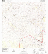 1993 Keamuku2001 Print · USGSThe volcanic high country of the Big Island is captured in the early nineties, showing a landscape defined by ranching, military training, and recreation. Local historians can trace the paths of Lightning Trail, the limits of the Keāmuku Lava Flow, and the grounds of the Kilohana Girl Scout Camp.
End of results
Showing maps 1-1 of 1
Frequently asked questions
- What are the different types of historical maps available for Ke‘āmuku?
- What is the oldest map of Ke‘āmuku?
- Where can I purchase historical maps of Ke‘āmuku for my home or office?
- Where can I download high-res historical maps of Ke‘āmuku?
- Are there historical topographic maps available for Ke‘āmuku?
- Is there historical aerial imagery available for Ke‘āmuku?
- Where are historical maps of Ke‘āmuku sourced from?