1980s Maps of Paniolo Estates, Hawaiʻi County
Explore 2 historic maps of Paniolo Estates from the 1980s. These maps offer a rare glimpse into what life looked like during the 1980s — showing old roads, neighborhoods, homes, and landmarks that have changed or disappeared over time.
Whether you're researching your family's past, planning a metal detecting trip, or studying how Paniolo Estates's landscape evolved across the 1980s, these high-resolution maps are a powerful tool for exploring the history of this region.
- Focus on a specific era: All maps on this page are from the 1980s, giving you a focused view of this time period.
- See what’s changed: Compare century-old streets, trails, and buildings to today's modern landscape using overlays and satellite layers.
- Research with precision: Use these maps for genealogy, historical research, land use analysis, or educational projects.
- View, download, or print: Maps are fully viewable online in high resolution, and can be downloaded or printed for your own records.
Start exploring Paniolo Estates's history through authentic maps from the 1980s. This is your window into the past.
Paniolo Estates, Hawaiʻi County maps
(2)- 1980 Map of Hawaii County Sheet 1, 1984 Print
 1980 Hawaii County Sheet 11984 Print · USGSThe Big Island's diverse terrain and transition into the 1980s are shown here, from the northern coast to the high mountain saddles. Genealogists and historians can trace homesteads and local roads near Kailua, Kukuihaele, and the Ahualoa area.
 - 1982 Map of Puu Hinai
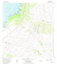 1982 Puu Hinai1982 Print · USGSThe South Kohala coast comes into focus in the early 1980s, showcasing a landscape defined by massive volcanic deposits and ancient aquaculture. Historians can trace the locations of traditional Waipuhi and Hopeaia Fishponds alongside the emerging community of Waikoloa.
End of results
Showing maps 1-2 of 2
Frequently asked questions
- What are the different types of historical maps available for Paniolo Estates?
- What is the oldest map of Paniolo Estates?
- Where can I purchase historical maps of Paniolo Estates for my home or office?
- Where can I download high-res historical maps of Paniolo Estates?
- Are there historical topographic maps available for Paniolo Estates?
- Is there historical aerial imagery available for Paniolo Estates?
- Where are historical maps of Paniolo Estates sourced from?