1900s (20th Century) Maps of Kawela, Honolulu County
Explore 9 historic maps of Kawela from the 1900s (20th Century). These maps offer a rare glimpse into what life looked like during the 1900s — showing old roads, neighborhoods, homes, and landmarks that have changed or disappeared over time.
Whether you're researching your family's past, planning a metal detecting trip, or studying how Kawela's landscape evolved across the 1900s, these high-resolution maps are a powerful tool for exploring the history of this region.
- Focus on a specific era: All maps on this page are from the 1900s, giving you a focused view of this time period.
- See what’s changed: Compare century-old streets, trails, and buildings to today's modern landscape using overlays and satellite layers.
- Research with precision: Use these maps for genealogy, historical research, land use analysis, or educational projects.
- View, download, or print: Maps are fully viewable online in high resolution, and can be downloaded or printed for your own records.
Start exploring Kawela's history through authentic maps from the 1900s. This is your window into the past.
Kawela, Honolulu County maps
(9)- 1954 Map of Oahu
 1954 Oahu1954 Print · USGSMid-century Oahu is caught between its plantation roots and its growing role as a Pacific military hub. Trace the OR and L Co rail lines and explore the 1950s footprints of Pearl Harbor, Libbyville, and Waipahu.
 - 1954 Map of Kahuku, 1955 Print
 1954 Kahuku1955 Print · USGSThe northern tip of Oahu is captured here in the mid-1950s, showing a landscape defined by sugar production and coastal military infrastructure. Genealogists and historians can trace local landmarks like the Sugar Mill, the Laie Temple, and the Hawaii Infantry Training Camp.
 - 1961 Map of Oahu
 1961 Oahu1961 Print · USGSOahu's strategic landscape is captured here during the early statehood era, showing the balance between burgeoning urban centers and massive military installations. Trace the path of the Oahu Railway and Land Co or locate historical sites like Schofield Barracks and Punchbowl Hill.
 - 1965 Map of Oahu
 1965 Oahu1965 Print · USGSOahu in the mid-sixties reveals a landscape defined by significant military installations and growing coastal communities. Researchers can trace the infrastructure of Pearl Harbor, Schofield Barracks, and landmarks like Diamond Head.2 unique versions available
 - 1965 Map of Kahuku, 1967 Print
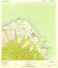
 1965 Kahuku1967 Print · USGSThe northern tip of Oahu is captured in the mid-sixties, showing the intersection of coastal development and the dense Koolau Range. You can trace the footprint of the Polynesian Cultural Center, locate the Sacred Heart Seminary, and follow the Old Railroad Grade through Kahuku.2 unique versions available
 - 1970 Map of Oahu, 1973 Print
 1970 Oahu1973 Print · USGSOahu was entering a new era of suburban and military expansion in the early seventies. Trace the growth of Mililani Town and Pearl City, or locate historic sites like Schofield Barracks and Diamond Head State Monument.2 unique versions available
 - 1977 Map of Kahuku, 1984 Print
 1977 Kahuku1984 Print · USGSThe northern reaches of Oahu are shown in detail during the late seventies, following the shoreline from the point through local settlements. Researchers can trace the exact building footprints and field patterns in Kahuku and Laie near Makahoa Point.
 - 1983 Map of Kahuku
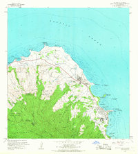
 1983 Kahuku1983 Print · USGSThe northern tip of Oahu comes into focus in the early 1980s, documenting a mix of university expansion and coastal conservation. Researchers can trace the grounds of Brigham Young University, the Laie Temple, and protected areas like Punamano Nat Wildlife Refuge.2 unique versions available
 - 1998 Map of Kahuku, 2000 Print
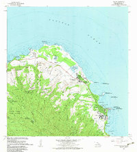
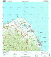 1998 Kahuku2000 Print · USGSOahu's North Shore and Windward Coast appear at the close of the century, showing a mix of institutional growth and shoreline preservation. Trace the development of La'ie near Brigham Young University or explore the Punamanō Nat Wildlife Refuge near Kahuku.
End of results
Showing maps 1-9 of 9
Frequently asked questions
- What are the different types of historical maps available for Kawela?
- What is the oldest map of Kawela?
- Where can I purchase historical maps of Kawela for my home or office?
- Where can I download high-res historical maps of Kawela?
- Are there historical topographic maps available for Kawela?
- Is there historical aerial imagery available for Kawela?
- Where are historical maps of Kawela sourced from?