1990s Maps of Mākaha Valley, Hawaii
Explore 1 historic maps of Mākaha Valley from the 1990s. These maps offer a rare glimpse into what life looked like during the 1990s — showing old roads, neighborhoods, homes, and landmarks that have changed or disappeared over time.
Whether you're researching your family's past, planning a metal detecting trip, or studying how Mākaha Valley's landscape evolved across the 1990s, these high-resolution maps are a powerful tool for exploring the history of this region.
- Focus on a specific era: All maps on this page are from the 1990s, giving you a focused view of this time period.
- See what’s changed: Compare century-old streets, trails, and buildings to today's modern landscape using overlays and satellite layers.
- Research with precision: Use these maps for genealogy, historical research, land use analysis, or educational projects.
- View, download, or print: Maps are fully viewable online in high resolution, and can be downloaded or printed for your own records.
Start exploring Mākaha Valley's history through authentic maps from the 1990s. This is your window into the past.
Mākaha Valley, HI maps
(1)- 1998 Map of Waianae, 2000 Print
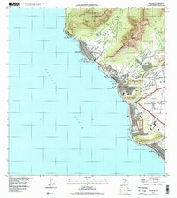 1998 Waianae2000 Print · USGSThe Leeward Coast of Oahu comes alive in the late nineties, showing the vital connection between the shoreline and the deep interior valleys. Trace family history through the Wai'anae Homesteads, locate the Naval Transmitting Facility, or find local landmarks like Pōka'ī Bay.
End of results
Showing maps 1-1 of 1
Top cities near Mākaha Valley
- Waipahu historical maps
- Mililani historical maps
- Kapolei historical maps
- Ewa Beach historical maps
- Waiʻanae historical maps
- Nānākuli historical maps
Frequently asked questions
- What are the different types of historical maps available for Mākaha Valley?
- What is the oldest map of Mākaha Valley?
- Where can I purchase historical maps of Mākaha Valley for my home or office?
- Where can I download high-res historical maps of Mākaha Valley?
- Are there historical topographic maps available for Mākaha Valley?
- Is there historical aerial imagery available for Mākaha Valley?
- Where are historical maps of Mākaha Valley sourced from?