Old Maps of Maunawili, Honolulu County for Academic Research
Study the evolution of Maunawili with 39 high-resolution historic maps. Whether you're teaching, researching, or modeling changes in land use, these maps provide essential visual documentation of urban, environmental, and geographic change.
- Analyze long-term change: Track patterns in development, transportation, and natural features.
- Ideal for environmental or urban studies: Support academic projects with primary historical map data.
- Use in the classroom or lab: Educators and researchers rely on these maps to bring historical context to life.
These maps are a powerful tool for teaching, research, and visualizing how Maunawili has changed over the decades.
Maunawili, Honolulu County maps
(39)- 1952 Map of Koko Head, 1954 Print
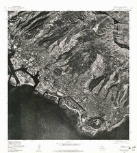
 1952 Koko Head1954 Print · USGSSoutheast Oahu's ridgelines and coastal plains are captured here in the early fifties, just as suburban expansion began reaching toward Koko Head. Researchers can trace early residential tracts like Aina Haina and the original footprint of Kuapa Pond or Waimanalo Village.
 - 1952 Map of Mokapu, 1954 Print
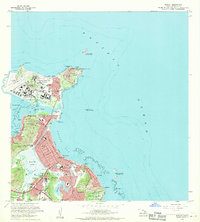
 1952 Mokapu1954 Print · USGSWindward Oahu's coastline is captured in the early fifties, showing the development of Kailua and Lanikai alongside major military installations. Genealogists and historians can trace local landmarks like the Heiau, Kailua Sky Ranch, and the Koolau Boys Home.
 - 1953 Map of Honolulu, 1956 Print
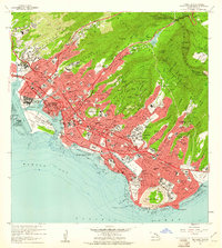
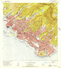 1953 Honolulu1956 Print · USGSMid-century Honolulu is captured here during a time of rapid urban expansion, from the bustling waterfront to the residential ridges. Researchers can trace the footprints of Fort Shafter, the historic Oahu Railway, and the early layout of the University of Hawaii.
 - 1954 Map of Oahu
 1954 Oahu1954 Print · USGSMid-century Oahu is caught between its plantation roots and its growing role as a Pacific military hub. Trace the OR and L Co rail lines and explore the 1950s footprints of Pearl Harbor, Libbyville, and Waipahu.
 - 1954 Map of Kaneohe, 1956 Print
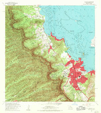
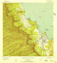 1954 Kaneohe1956 Print · USGSWindward Oahu in the mid-fifties shows a landscape of mountain homesteads and expanding coastal settlements. Trace family land in the Waiahole Homesteads or locate local landmarks like the Territorial Hospital and the Heeia Radio Station.
 - 1959 Map of Mokapu, 1960 Print
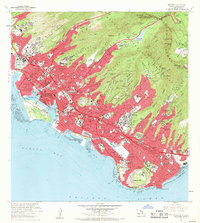
 1959 Mokapu1960 Print · USGSCoastal Oahu at the dawn of the 1960s reveals a mix of military installations and burgeoning seaside communities. Local historians can trace the early layouts of Lanikai and Kailua, alongside landmarks like the Kailua Sky Ranch and Bellows Air Force Base.2 unique versions available
 - 1959 Map of Koko Head, 1960 Print
 1959 Koko Head1960 Print · USGSSoutheastern Oahu in the late fifties shows a landscape of military bases and coastal growth before the major transformation of its ancient fishponds. Trace early neighborhood developments in Aina Haina and Portlock, or locate landmarks like Kuapa Pond and Koko Crater.
 - 1959 Map of Kaneohe, 1961 Print
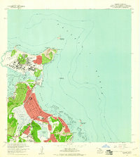
 1959 Kaneohe1961 Print · USGSCoastal Oahu in the late fifties shows a mix of growing residential communities and traditional Hawaiian fishponds. Genealogists and historians can trace family roots through the Kokokahi Homesteads, locate old landmarks like St Anns Sch, or study the footprint of the State Hospital.
 - 1959 Map of Honolulu, 1961 Print
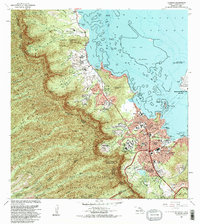
 1959 Honolulu1961 Print · USGSMid-century Honolulu is captured here during a transition toward modern statehood, showing a dense city bounded by the Koolau peaks and the Pacific. Trace the footprints of the Oahu Railway and Land Co, Iolani Palace, and Diamond Head.
 - 1961 Map of Oahu
 1961 Oahu1961 Print · USGSOahu's strategic landscape is captured here during the early statehood era, showing the balance between burgeoning urban centers and massive military installations. Trace the path of the Oahu Railway and Land Co or locate historical sites like Schofield Barracks and Punchbowl Hill.
 - 1965 Map of Oahu
 1965 Oahu1965 Print · USGSOahu in the mid-sixties reveals a landscape defined by significant military installations and growing coastal communities. Researchers can trace the infrastructure of Pearl Harbor, Schofield Barracks, and landmarks like Diamond Head.2 unique versions available
 - 1968 Map of Mokapu, 1970 Print
 1968 Mokapu1970 Print · USGSCoastal Oahu in the late sixties reveals a mix of expanding suburbs and significant military installations along the Windward shore. Local researchers can trace residential growth in Kailua, explore the Kawainui Swamp basin, or locate landmarks like Ulupau Crater and St Anthony Sch.2 unique versions available
 - 1968 Map of Kaneohe, 1970 Print
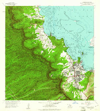
 1968 Kaneohe1970 Print · USGSWindward Oahu's coastline and valleys are captured here in the late sixties as traditional homesteads and modern developments meet. Trace family roots and land use through the Waiahole Homesteads, the Byodo-In Temple, and Puohala Village.2 unique versions available
 - 1969 Map of Honolulu, 1971 Print
 1969 Honolulu1971 Print · USGSIn the late 1960s, Honolulu’s modern skyline was rising against the backdrop of ancient volcanic craters and steep emerald ridges. Researchers can trace the mid-century city layout, identifying landmarks like Diamond Head, the Punchbowl, and the Aloha Tower.2 unique versions available
 - 1969 Map of Koko Head, 1971 Print
 1969 Koko Head1971 Print · USGSSoutheastern Oahu undergoes a period of rapid suburban transformation in the late sixties as new coastal developments take root. Researchers can trace the early footprint of Hawaii Kai, the grounds of the Kawailoa Girls Home, and landmarks like Makapuu Point.
 - 1970 Map of Oahu, 1973 Print
 1970 Oahu1973 Print · USGSOahu was entering a new era of suburban and military expansion in the early seventies. Trace the growth of Mililani Town and Pearl City, or locate historic sites like Schofield Barracks and Diamond Head State Monument.2 unique versions available
 - 1978 Map of Mokapu, 1981 Print
 1978 Mokapu1981 Print · USGSThe windward coast of Oahu comes into focus during the late seventies through this detailed aerial orthophotoquad. Local researchers can trace the development of coastal neighborhoods and the exact footprint of Kawainui Swamp during this era.
 - 1978 Map of Koko Head, 1981 Print
 1978 Koko Head1981 Print · USGSSoutheastern Oahu in the late seventies reveals a landscape of rapid suburban growth set against ancient volcanic landmarks. Researchers can trace development patterns around Maunalua Bay and study the terrain of Koko Head and Olomana Peak.
 - 1978 Map of Honolulu, 1981 Print
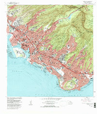
 1978 Honolulu1981 Print · USGSThe city of Honolulu is captured in sharp aerial detail during the mid-seventies, showing the urban landscape from the harbor to the mountains. Researchers can trace development patterns around the iconic DIAMOND HEAD crater and the heights of KONAHUANUI.
 - 1983 Map of Koko Head
 1983 Koko Head1983 Print · USGSSoutheastern Oahu in the early eighties shows a landscape of rapid coastal change and suburban expansion. Researchers can trace the development of Hawaii Kai and locate historical institutions like the Kawailoa Girls Home and Bellows Air Force Station.
 - 1983 Map of Mokapu
 1983 Mokapu1983 Print · USGSWindward Oahu in the early eighties shows a landscape defined by military installations and suburban growth along the coast. Researchers can find cultural landmarks like Ulupo Heiau, early residential areas such as Keolu Hills, and the Kailua Boys Home.
 - 1983 Map of Kaneohe
 1983 Kaneohe1983 Print · USGSCoastal Oahu in the early 1980s reveals a transition from traditional homesteads to modern suburban centers along the windward shore. Researchers can trace the development of Kaneohe and Puoala Village alongside landmarks like the Byodo-In Temple and Hoomaluhia Park.2 unique versions available
 - 1983 Map of Honolulu, 1986 Print
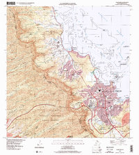
 1983 Honolulu1986 Print · USGSHonolulu in the early eighties shows a dense urban sprawl climbing into the volcanic ridges of the Koolau Range. Genealogists and historians can trace the footprints of Kamehameha Schools, Punahou School, and landmark cemeteries like Oahu Cem.
 - 1998 Map of Mokapu Point, 2000 Print
 1998 Mokapu Point2000 Print · USGSWindward Oahu at the close of the century shows a unique coastal landscape shaped by military presence and suburban growth. Trace local landmarks like the Marine Corps Base Hawaii, Kawainui Marsh, and the Ulukoi Heiau State Monument.
 - 1998 Map of Kaneohe, 2000 Print
 1998 Kaneohe2000 Print · USGSWindward Oahu at the close of the century reveals a landscape where suburban Kaneohe meets historic coastal homesteads and mountain reserves. Trace local genealogy and land use through the Waiahole Homesteads, Byodo-In Temple, and Pu‘ohala Village.
Showing maps 1-25 of 39
Frequently asked questions
- What are the different types of historical maps available for Maunawili?
- What is the oldest map of Maunawili?
- Where can I purchase historical maps of Maunawili for my home or office?
- Where can I download high-res historical maps of Maunawili?
- Are there historical topographic maps available for Maunawili?
- Is there historical aerial imagery available for Maunawili?
- Where are historical maps of Maunawili sourced from?