Old Maps of Waiale‘e, Hawaii for Academic Research
Study the evolution of Waiale‘e with 12 high-resolution historic maps. Whether you're teaching, researching, or modeling changes in land use, these maps provide essential visual documentation of urban, environmental, and geographic change.
- Analyze long-term change: Track patterns in development, transportation, and natural features.
- Ideal for environmental or urban studies: Support academic projects with primary historical map data.
- Use in the classroom or lab: Educators and researchers rely on these maps to bring historical context to life.
These maps are a powerful tool for teaching, research, and visualizing how Waiale‘e has changed over the decades.
Waiale‘e, HI maps
(12)- 1952 Map of Waimea, 1954 Print
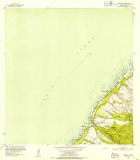 1952 Waimea1954 Print · USGSOahu's North Shore in the early fifties shows the early residential framing of Sunset Beach and the rugged forest reserves of the interior. Trace historic sites like Puu o Mahuka Heiau and follow the route of Kamehameha Highway past Waimea Bay.2 unique versions available
 - 1954 Map of Oahu
 1954 Oahu1954 Print · USGSMid-century Oahu is caught between its plantation roots and its growing role as a Pacific military hub. Trace the OR and L Co rail lines and explore the 1950s footprints of Pearl Harbor, Libbyville, and Waipahu.
 - 1961 Map of Oahu
 1961 Oahu1961 Print · USGSOahu's strategic landscape is captured here during the early statehood era, showing the balance between burgeoning urban centers and massive military installations. Trace the path of the Oahu Railway and Land Co or locate historical sites like Schofield Barracks and Punchbowl Hill.
 - 1965 Map of Oahu
 1965 Oahu1965 Print · USGSOahu in the mid-sixties reveals a landscape defined by significant military installations and growing coastal communities. Researchers can trace the infrastructure of Pearl Harbor, Schofield Barracks, and landmarks like Diamond Head.2 unique versions available
 - 1966 Map of Waimea, 1967 Print
 1966 Waimea1967 Print · USGSThe North Shore of Oahu in the mid-1960s reveals a landscape of ancient sacred sites and burgeoning coastal settlements. Researchers can trace the heritage of Puu O Mahuka Heiau, the expanse of Kalou Marsh, and the grounds of Camp Pupukea.
 - 1970 Map of Oahu, 1973 Print
 1970 Oahu1973 Print · USGSOahu was entering a new era of suburban and military expansion in the early seventies. Trace the growth of Mililani Town and Pearl City, or locate historic sites like Schofield Barracks and Diamond Head State Monument.2 unique versions available
 - 1977 Map of Waimea, 1984 Print
 1977 Waimea1984 Print · USGSThe North Shore of Oahu is captured in detail during the late seventies, showing the transition of this famous coastline before modern development. Researchers can trace the layout of Waimea and the beachfront at Kawailoa Beach alongside the waters of Waimea Bay.
 - 1983 Map of Waimea
 1983 Waimea1983 Print · USGSThe North Shore of Oahu in the early eighties shows a landscape of world-famous beaches and deep cultural heritage. Trace the coastline from Sunset Beach down to Waimea Bay, locating ancient sites like Kupupolo Heiau and the grounds of Waimea Falls.2 unique versions available
 - 1998 Map of Waimea, 2000 Print
 1998 Waimea2000 Print · USGSThe North Shore of Oahu comes into focus in the late nineties, showing the established coastal communities and the preserved uplands. Trace the development of Pupukea Homesteads and find landmarks like Sunset Beach Sch and the Pu'uomahuka State Monument.
 - 2013 Map of Waimea, 2013 Print
 2013 Waimea2013 Print · USGSCovers Waiale‘e, including Honolulu County, United States, and other nearby areas
 - 2017 Map of Waimea, 2017 Print
 2017 Waimea2017 Print · USGSCovers Waiale‘e, including Honolulu County, United States, and other nearby areas
 - 2024 Map of Waimea, 2024 Print
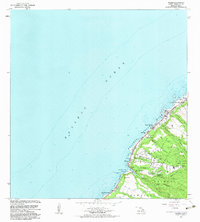
 2024 Waimea2024 Print · USGSThe North Shore of O'ahu is documented here in the mid-2020s, showing the intersection of coastal settlements and the island's steep interior gulches. Researchers can trace the path of the Waimea River to Waimea Falls or explore the residential layouts of Sunset Beach and Pupukea.
End of results
Showing maps 1-12 of 12
Frequently asked questions
- What are the different types of historical maps available for Waiale‘e?
- What is the oldest map of Waiale‘e?
- Where can I purchase historical maps of Waiale‘e for my home or office?
- Where can I download high-res historical maps of Waiale‘e?
- Are there historical topographic maps available for Waiale‘e?
- Is there historical aerial imagery available for Waiale‘e?
- Where are historical maps of Waiale‘e sourced from?