1950s Maps of Waipahu, Hawaii
Explore 3 historic maps of Waipahu from the 1950s. These maps offer a rare glimpse into what life looked like during the 1950s — showing old roads, neighborhoods, homes, and landmarks that have changed or disappeared over time.
Whether you're researching your family's past, planning a metal detecting trip, or studying how Waipahu's landscape evolved across the 1950s, these high-resolution maps are a powerful tool for exploring the history of this region.
- Focus on a specific era: All maps on this page are from the 1950s, giving you a focused view of this time period.
- See what’s changed: Compare century-old streets, trails, and buildings to today's modern landscape using overlays and satellite layers.
- Research with precision: Use these maps for genealogy, historical research, land use analysis, or educational projects.
- View, download, or print: Maps are fully viewable online in high resolution, and can be downloaded or printed for your own records.
Start exploring Waipahu's history through authentic maps from the 1950s. This is your window into the past.
Waipahu, HI maps
(3)- 1954 Map of Oahu
 1954 Oahu1954 Print · USGSMid-century Oahu is caught between its plantation roots and its growing role as a Pacific military hub. Trace the OR and L Co rail lines and explore the 1950s footprints of Pearl Harbor, Libbyville, and Waipahu.
 - 1954 Map of Waipahu, 1956 Print
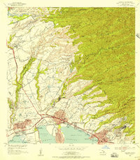 1954 Waipahu1956 Print · USGSOahu's south-central coastline and plantation interior are documented in the mid-fifties during a period of industrial and military growth. Genealogists and historians can trace rail lines like the Oahu Railway and industry sites like the Sugar Refinery and Waipio Camp A.
 - 1959 Map of Waipahu, 1961 Print
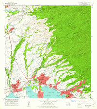 1959 Waipahu1961 Print · USGSCentral Oahu in the late fifties reveals a landscape defined by sugar plantations, pineapple research, and massive military installations. Researchers can trace the water network of the Waiahole Ditch, find the old Sugar Refinery, and locate the Kipapa Airfield near Waipio Acres.
End of results
Showing maps 1-3 of 3
Top cities near Waipahu
- Honolulu historical maps
- Mililani historical maps
- Pearl City historical maps
- Kaneohe historical maps
- Kapolei historical maps
- Aiea historical maps
See more
Frequently asked questions
- What are the different types of historical maps available for Waipahu?
- What is the oldest map of Waipahu?
- Where can I purchase historical maps of Waipahu for my home or office?
- Where can I download high-res historical maps of Waipahu?
- Are there historical topographic maps available for Waipahu?
- Is there historical aerial imagery available for Waipahu?
- Where are historical maps of Waipahu sourced from?