1980s Maps of Sweet, Idaho
Explore 2 historic maps of Sweet from the 1980s. These maps offer a rare glimpse into what life looked like during the 1980s — showing old roads, neighborhoods, homes, and landmarks that have changed or disappeared over time.
Whether you're researching your family's past, planning a metal detecting trip, or studying how Sweet's landscape evolved across the 1980s, these high-resolution maps are a powerful tool for exploring the history of this region.
- Focus on a specific era: All maps on this page are from the 1980s, giving you a focused view of this time period.
- See what’s changed: Compare century-old streets, trails, and buildings to today's modern landscape using overlays and satellite layers.
- Research with precision: Use these maps for genealogy, historical research, land use analysis, or educational projects.
- View, download, or print: Maps are fully viewable online in high resolution, and can be downloaded or printed for your own records.
Start exploring Sweet's history through authentic maps from the 1980s. This is your window into the past.
Sweet, ID maps
(2)- 1981 Map of Boise
 1981 Boise1981 Print · USGSThe Boise River valley and Treasure Plain are captured here in the early eighties as urban expansion began to link the regional hubs of the Snake River plain. Researchers can trace the development of Nampa, Caldwell, and Meridian or locate landmarks like Lake Lowell and Eagle Island State Park.2 unique versions available
 - 1985 Map of Montour, 1986 Print
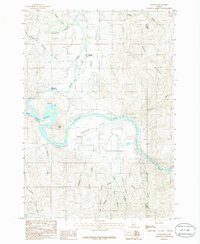 1985 Montour1986 Print · USGSThe Payette River and Sweet Valley are captured here in the mid-1980s, showcasing the intersection of canyon terrain and riverside settlement. Genealogists and researchers can trace local landmarks like Roystone Hot Springs, the community of Sweet, and the waters of Black Canyon Reservoir.
End of results
Showing maps 1-2 of 2
Top cities near Sweet
Frequently asked questions
- What are the different types of historical maps available for Sweet?
- What is the oldest map of Sweet?
- Where can I purchase historical maps of Sweet for my home or office?
- Where can I download high-res historical maps of Sweet?
- Are there historical topographic maps available for Sweet?
- Is there historical aerial imagery available for Sweet?
- Where are historical maps of Sweet sourced from?