1900s (20th Century) Maps of Grand View, Idaho
Explore 8 historic maps of Grand View from the 1900s (20th Century). These maps offer a rare glimpse into what life looked like during the 1900s — showing old roads, neighborhoods, homes, and landmarks that have changed or disappeared over time.
Whether you're researching your family's past, planning a metal detecting trip, or studying how Grand View's landscape evolved across the 1900s, these high-resolution maps are a powerful tool for exploring the history of this region.
- Focus on a specific era: All maps on this page are from the 1900s, giving you a focused view of this time period.
- See what’s changed: Compare century-old streets, trails, and buildings to today's modern landscape using overlays and satellite layers.
- Research with precision: Use these maps for genealogy, historical research, land use analysis, or educational projects.
- View, download, or print: Maps are fully viewable online in high resolution, and can be downloaded or printed for your own records.
Start exploring Grand View's history through authentic maps from the 1900s. This is your window into the past.
Grand View, ID maps
(8)- 1947 Map of Grand View, 1952 Print
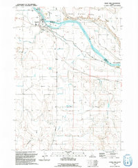
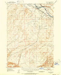 1947 Grand View1952 Print · USGSOwyhee County ranching and irrigation are captured here at the end of the 1940s, centered on the riverfront settlement of Grand View. Researchers can trace early family holdings like Whitson Ranch or find the Cem and Landing Strip near the banks of the Snake River.2 unique versions available
 - 1947 Map of Grand View, 1966 Print
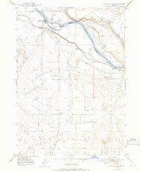 1947 Grand View1966 Print · USGSOwyhee County's high desert meets the river's edge in the late 1940s, revealing an era of expanding irrigation and ranching. Genealogists and historians can trace family land at Whitson Ranch, locate the Cem, or study the early engineering of the Low Line Canal.3 unique versions available
 - 1948 Map of Grand View
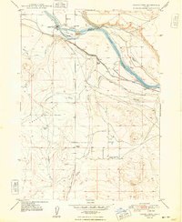 1948 Grand View1948 Print · USGSThe high desert of Owyhee County was a land of ranching and irrigation in the late 1940s. Genealogists and researchers can trace family-named homesteads such as Dixie Ranch and Whitson Ranch, alongside vital water sources like Artesian Wells and Hinton Res.
 - 1955 Map of Jordan Valley, 1963 Print
 1955 Jordan Valley1963 Print · USGSThe high desert of Malheur County comes alive in the mid-1950s, showing the isolated ranching outposts and deep canyons along the Idaho border. Researchers can trace the remote reaches of the Owyhee River, the cattle town of Jordan Valley, and mining landmarks like War Eagle Mountain.3 unique versions available
 - 1957 Map of Jordan Valley
 1957 Jordan Valley1957 Print · USGSThe high-desert borderlands of Oregon and Idaho appear in the mid-fifties as a world of remote cattle ranches and mining claims. Researchers can trace historic family-named locations like Bowden Ranch and Riddle alongside the South Mountain Mining Company.
 - 1958 Map of Jordan Valley
 1958 Jordan Valley1958 Print · USGSSoutheast Oregon and Southwest Idaho are documented here during the mid-fifties, showing a landscape of remote cattle ranches and volcanic badlands. Genealogists and historians can trace family operations like the Bowden Ranch or locate the Pleasant Valley School and the South Mountain Mining Company.2 unique versions available
 - 1990 Map of Triangle
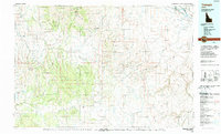 1990 Triangle1990 Print · USGSThe Owyhee high desert is captured here in the late twentieth century, showing a vast network of canyonlands and isolated settlements. Researchers can trace historic mining activity at Black Warrior Mine and the remote outpost of Triangle amidst the Owyhee Mountains.
 - 1992 Map of Grand View
 1992 Grand View1992 Print · USGSNear the high-desert banks of the Snake River in the early nineties, this Idaho landscape reveals a unique mix of geothermal energy and river-fed ranching. Genealogists and local historians can trace family operations at Dixie Ranch, the community cemetery, and the local rodeo grounds.
End of results
Showing maps 1-8 of 8
Frequently asked questions
- What are the different types of historical maps available for Grand View?
- What is the oldest map of Grand View?
- Where can I purchase historical maps of Grand View for my home or office?
- Where can I download high-res historical maps of Grand View?
- Are there historical topographic maps available for Grand View?
- Is there historical aerial imagery available for Grand View?
- Where are historical maps of Grand View sourced from?