1990s Maps of West Noblesville, Noblesville
Explore 2 historic maps of West Noblesville from the 1990s. These maps offer a rare glimpse into what life looked like during the 1990s — showing old roads, neighborhoods, homes, and landmarks that have changed or disappeared over time.
Whether you're researching your family's past, planning a metal detecting trip, or studying how West Noblesville's landscape evolved across the 1990s, these high-resolution maps are a powerful tool for exploring the history of this region.
- Focus on a specific era: All maps on this page are from the 1990s, giving you a focused view of this time period.
- See what’s changed: Compare century-old streets, trails, and buildings to today's modern landscape using overlays and satellite layers.
- Research with precision: Use these maps for genealogy, historical research, land use analysis, or educational projects.
- View, download, or print: Maps are fully viewable online in high resolution, and can be downloaded or printed for your own records.
Start exploring West Noblesville's history through authentic maps from the 1990s. This is your window into the past.
West Noblesville, Noblesville maps
(2)- 1992 Map of Noblesville, 1995 Print
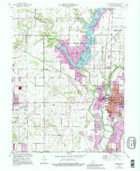 1992 Noblesville1995 Print · USGSHamilton County experienced significant shifts in the early nineties as the area around Noblesville bridged its rural past and suburban future. Genealogists can trace family sites at Crownland Cem and Weaver Cem, or locate landmarks like Potter Bridge and the Stony Creek Sch.
 - 1998 Map of Noblesville, 2002 Print
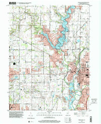 1998 Noblesville2002 Print · USGSNoblesville and the surrounding Hamilton County countryside are shown here at the close of the twentieth century. Researchers can trace development around Morse Reservoir or locate historical sites like Potter Bridge and Gray Friends Ch.
End of results
Showing maps 1-2 of 2
Frequently asked questions
- What are the different types of historical maps available for West Noblesville?
- What is the oldest map of West Noblesville?
- Where can I purchase historical maps of West Noblesville for my home or office?
- Where can I download high-res historical maps of West Noblesville?
- Are there historical topographic maps available for West Noblesville?
- Is there historical aerial imagery available for West Noblesville?
- Where are historical maps of West Noblesville sourced from?