1960s Maps of Ambridge Mann, Gary
Explore 2 historic maps of Ambridge Mann from the 1960s. These maps offer a rare glimpse into what life looked like during the 1960s — showing old roads, neighborhoods, homes, and landmarks that have changed or disappeared over time.
Whether you're researching your family's past, planning a metal detecting trip, or studying how Ambridge Mann's landscape evolved across the 1960s, these high-resolution maps are a powerful tool for exploring the history of this region.
- Focus on a specific era: All maps on this page are from the 1960s, giving you a focused view of this time period.
- See what’s changed: Compare century-old streets, trails, and buildings to today's modern landscape using overlays and satellite layers.
- Research with precision: Use these maps for genealogy, historical research, land use analysis, or educational projects.
- View, download, or print: Maps are fully viewable online in high resolution, and can be downloaded or printed for your own records.
Start exploring Ambridge Mann's history through authentic maps from the 1960s. This is your window into the past.
Ambridge Mann, Gary maps
(2)- 1968 Map of Gary, 1970 Print
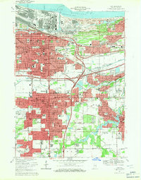 1968 Gary1970 Print · USGSSteel and rail defined the Indiana lakefront in the late sixties as neighborhoods expanded south from Lake Michigan. Genealogists can locate family homes and landmarks like Oak Hill Cemetery, Sacred Heart Sch, and the Indiana Harbor Belt rail lines.3 unique versions available
 - 1968 Map of Highland, 1971 Print
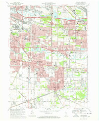 1968 Highland1971 Print · USGSNorthwest Indiana during the late sixties shows a dense network of rail lines and early interstate highways connecting growing industrial suburbs. Genealogists and historians can trace numerous community landmarks from St Marys Cem to the Purdue University (Calumet Center).3 unique versions available
End of results
Showing maps 1-2 of 2
Top cities near Ambridge Mann
- Chicago historical maps
- Hammond historical maps
- Gary historical maps
- Portage historical maps
- Calumet City historical maps
- Merrillville historical maps
See more
Top neighborhoods of Ambridge Mann
- Ambridge Mann historical maps
- Ambridge historical maps
- Horace Mann historical maps
- Westbrook historical maps
- Waverly Park historical maps
Frequently asked questions
- What are the different types of historical maps available for Ambridge Mann?
- What is the oldest map of Ambridge Mann?
- Where can I purchase historical maps of Ambridge Mann for my home or office?
- Where can I download high-res historical maps of Ambridge Mann?
- Are there historical topographic maps available for Ambridge Mann?
- Is there historical aerial imagery available for Ambridge Mann?
- Where are historical maps of Ambridge Mann sourced from?