1970s Maps of Heltonville, Indiana
Explore 1 historic maps of Heltonville from the 1970s. These maps offer a rare glimpse into what life looked like during the 1970s — showing old roads, neighborhoods, homes, and landmarks that have changed or disappeared over time.
Whether you're researching your family's past, planning a metal detecting trip, or studying how Heltonville's landscape evolved across the 1970s, these high-resolution maps are a powerful tool for exploring the history of this region.
- Focus on a specific era: All maps on this page are from the 1970s, giving you a focused view of this time period.
- See what’s changed: Compare century-old streets, trails, and buildings to today's modern landscape using overlays and satellite layers.
- Research with precision: Use these maps for genealogy, historical research, land use analysis, or educational projects.
- View, download, or print: Maps are fully viewable online in high resolution, and can be downloaded or printed for your own records.
Start exploring Heltonville's history through authentic maps from the 1970s. This is your window into the past.
Heltonville, IN maps
(1)- 1978 Map of Bartlettsville, 1979 Print
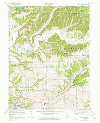 1978 Bartlettsville1979 Print · USGSIn the late 1970s, the rural landscapes of Lawrence County remained centered around small settlements and the timbered hills of the Hoosier National Forest. Genealogists and historians can trace family locations through numerous sites like Covey Cem, Ramsey Ridge Ch, and the old rail corridor of the Chicago Milwaukee St Paul and Pacific.3 unique versions available
End of results
Showing maps 1-1 of 1
Top cities near Heltonville
- Bloomington historical maps
- Bedford historical maps
- Mitchell historical maps
- Clear Creek historical maps
- Guthrie historical maps
- Oolitic historical maps
See more
Frequently asked questions
- What are the different types of historical maps available for Heltonville?
- What is the oldest map of Heltonville?
- Where can I purchase historical maps of Heltonville for my home or office?
- Where can I download high-res historical maps of Heltonville?
- Are there historical topographic maps available for Heltonville?
- Is there historical aerial imagery available for Heltonville?
- Where are historical maps of Heltonville sourced from?