1990s Maps of Marion County, Indiana
Explore 10 historic maps of Marion County from the 1990s. These maps offer a rare glimpse into what life looked like during the 1990s — showing old roads, neighborhoods, homes, and landmarks that have changed or disappeared over time.
Whether you're researching your family's past, planning a metal detecting trip, or studying how Marion County's landscape evolved across the 1990s, these high-resolution maps are a powerful tool for exploring the history of this region.
- Focus on a specific era: All maps on this page are from the 1990s, giving you a focused view of this time period.
- See what’s changed: Compare century-old streets, trails, and buildings to today's modern landscape using overlays and satellite layers.
- Research with precision: Use these maps for genealogy, historical research, land use analysis, or educational projects.
- View, download, or print: Maps are fully viewable online in high resolution, and can be downloaded or printed for your own records.
Start exploring Marion County's history through authentic maps from the 1990s. This is your window into the past.
Marion County, IN maps
(10)- 1998 Map of Bridgeport, 2000 Print
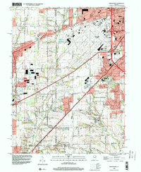 1998 Bridgeport2000 Print · USGSThe outskirts of Indianapolis and Mooresville are shown here during the late nineties as suburban growth reached the Hendricks County line. Researchers can trace historic local sites like Seerley Cem and Friends Cem or the older street grids of West Newton and Mickleyville.
 - 1998 Map of Fishers, 2000 Print
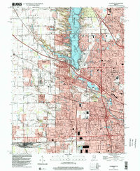
 1998 Fishers2000 Print · USGSThe northern edge of the Indianapolis metro area is shown here in the late nineties as residential growth transforms the White River valley. Genealogists and local historians can locate legacy sites like New Britton, White Chapel, and the historic Heady Cem alongside modern landmarks.
 - 1998 Map of Indianapolis East, 2001 Print
 1998 Indianapolis East2001 Print · USGSMarion County’s eastern suburbs and urban neighborhoods are captured here in the late nineties as a fully realized landscape of industry and community. Researchers can locate dozens of parish schools and historic burial grounds like Fall Creek Cemetery or trace the sprawling U S Naval Reservation.
 - 1998 Map of Zionsville, 2001 Print
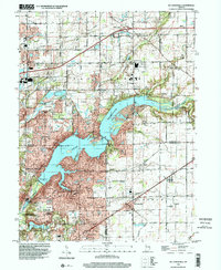
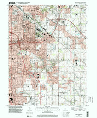
 1998 Zionsville2001 Print · USGSBoone and Marion counties are captured in the late 1990s as the suburbs of Indianapolis expanded north toward Zionsville. Researchers can trace historic family plots like Jones Cem, local landmarks like Macedonia Ch, and the vast Eagle Creek Reservoir shoreline.
 - 1998 Map of Clermont, 2002 Print
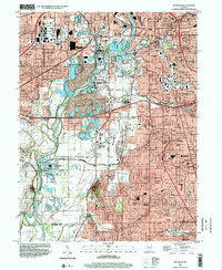
 1998 Clermont2002 Print · USGSMarion County at the close of the century shows a landscape defined by the intersection of suburban growth and major infrastructure. Trace the development of Clermont, Speedway, and the Big Four Yard rail complex alongside Eagle Creek Reservoir.
 - 1998 Map of Mc Cordsville, 2002 Print
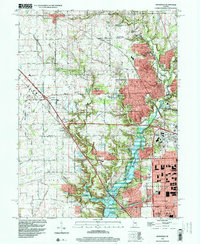
 1998 Mc Cordsville2002 Print · USGSThe growing communities northeast of Indianapolis come into focus here during the late nineties as residential development meets rural heritage. Genealogists and local historians can trace family plots like Arnett Cem or explore the early layouts of Woodbury and McCordsville along the Conrail tracks.
 - 1998 Map of Carmel, 2002 Print
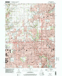 1998 Carmel2002 Print · USGSThe northern edge of Indianapolis meets Carmel during a period of rapid suburban growth in the late nineties. Genealogists and local historians can trace residential developments like Home Place alongside landmarks such as Eagle Village and Our Lady of Mt Carmel Sch.
 - 1998 Map of Maywood, 2002 Print
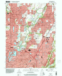
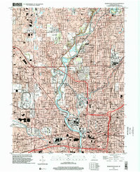
 1998 Maywood2002 Print · USGSThe southern suburbs of Indianapolis and the White River valley are captured here in the late 1990s as residential growth meets legacy industry. Researchers can locate family roots at Hebrew Cemetery or trace the early footprint of Indiana Central College and Stout Field.
 - 1998 Map of Beech Grove, 2002 Print
 1998 Beech Grove2002 Print · USGSSoutheast of Indianapolis in the late nineties, this area reveals a landscape of maturing suburbs and industrial rail corridors. Genealogists can trace family sites near New Crown Cemetery, Wanamaker, and St Johns Cem & Ch.
 - 1998 Map of Indianapolis West, 2002 Print
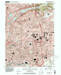
 1998 Indianapolis West2002 Print · USGSIndianapolis and the town of Speedway are shown at a peak of late-century development, where the river meets the rail lines of CONRAIL. Trace historic school sites like Attucks High Sch and the expansive grounds of Crown Hill Cemetery.
End of results
Showing maps 1-10 of 10
Top cities of Marion County
Frequently asked questions
- What are the different types of historical maps available for Marion County?
- What is the oldest map of Marion County?
- Where can I purchase historical maps of Marion County for my home or office?
- Where can I download high-res historical maps of Marion County?
- Are there historical topographic maps available for Marion County?
- Is there historical aerial imagery available for Marion County?
- Where are historical maps of Marion County sourced from?