1960s Maps of Converse, Indiana
Explore 2 historic maps of Converse from the 1960s. These maps offer a rare glimpse into what life looked like during the 1960s — showing old roads, neighborhoods, homes, and landmarks that have changed or disappeared over time.
Whether you're researching your family's past, planning a metal detecting trip, or studying how Converse's landscape evolved across the 1960s, these high-resolution maps are a powerful tool for exploring the history of this region.
- Focus on a specific era: All maps on this page are from the 1960s, giving you a focused view of this time period.
- See what’s changed: Compare century-old streets, trails, and buildings to today's modern landscape using overlays and satellite layers.
- Research with precision: Use these maps for genealogy, historical research, land use analysis, or educational projects.
- View, download, or print: Maps are fully viewable online in high resolution, and can be downloaded or printed for your own records.
Start exploring Converse's history through authentic maps from the 1960s. This is your window into the past.
Converse, IN maps
(2)- 1962 Map of Amboy, 1963 Print
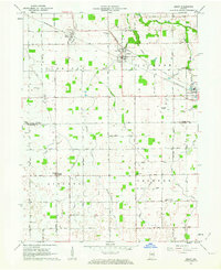 1962 Amboy1963 Print · USGSMiami and Howard counties appear here in the early sixties as a thriving rail-and-farming landscape. Genealogists and local historians can trace family-named sites like Herchberger Cem, visit North Grove Ch, or follow the Pennsylvania Railroad through Amboy.2 unique versions available
 - 1962 Map of Sweetser, 1963 Print
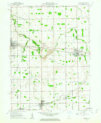 1962 Sweetser1963 Print · USGSGrant County in the early sixties was a hub of rural industry and local rail transport. Genealogists and historians can trace family roots at Thrailkill Cemetery, explore the rail sidings of Swayzee, or locate the Richland Chapel and Oak Hill High School.
End of results
Showing maps 1-2 of 2
Top cities near Converse
- Kokomo historical maps
- Marion historical maps
- Peru historical maps
- Wabash historical maps
- Fairmount historical maps
- Greentown historical maps
See more
Frequently asked questions
- What are the different types of historical maps available for Converse?
- What is the oldest map of Converse?
- Where can I purchase historical maps of Converse for my home or office?
- Where can I download high-res historical maps of Converse?
- Are there historical topographic maps available for Converse?
- Is there historical aerial imagery available for Converse?
- Where are historical maps of Converse sourced from?