1970s Maps of Fillmore, Indiana
Explore 2 historic maps of Fillmore from the 1970s. These maps offer a rare glimpse into what life looked like during the 1970s — showing old roads, neighborhoods, homes, and landmarks that have changed or disappeared over time.
Whether you're researching your family's past, planning a metal detecting trip, or studying how Fillmore's landscape evolved across the 1970s, these high-resolution maps are a powerful tool for exploring the history of this region.
- Focus on a specific era: All maps on this page are from the 1970s, giving you a focused view of this time period.
- See what’s changed: Compare century-old streets, trails, and buildings to today's modern landscape using overlays and satellite layers.
- Research with precision: Use these maps for genealogy, historical research, land use analysis, or educational projects.
- View, download, or print: Maps are fully viewable online in high resolution, and can be downloaded or printed for your own records.
Start exploring Fillmore's history through authentic maps from the 1970s. This is your window into the past.
Fillmore, IN maps
(2)- 1970 Map of Coatesville, 1972 Print
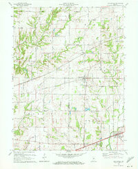 1970 Coatesville1972 Print · USGSIndiana farmland and rail corridors define the landscape between Coatesville and Stilesville during the early 1970s. Trace the paths of the National Road and the Penn Central tracks past local landmarks like Bethel Ch and Sunset Lake.3 unique versions available
 - 1970 Map of Greencastle, 1972 Print
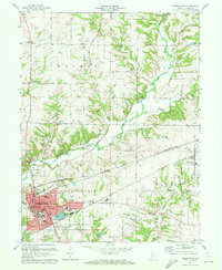 1970 Greencastle1972 Print · USGSGreencastle and its surrounding townships are shown here during a period of mid-century growth and industrial activity. Genealogists and local historians can trace the Monon railroad line, find family plots at Forest Hill Cem, or locate historic crossings like the Bakers Camp Covered Bridge.3 unique versions available
End of results
Showing maps 1-2 of 2
Top cities near Fillmore
- Greencastle historical maps
- Danville historical maps
- Cloverdale historical maps
- Roachdale historical maps
- Clayton historical maps
- North Salem historical maps
See more
Frequently asked questions
- What are the different types of historical maps available for Fillmore?
- What is the oldest map of Fillmore?
- Where can I purchase historical maps of Fillmore for my home or office?
- Where can I download high-res historical maps of Fillmore?
- Are there historical topographic maps available for Fillmore?
- Is there historical aerial imagery available for Fillmore?
- Where are historical maps of Fillmore sourced from?