1970s Maps of Atlantic, Iowa
Explore 2 historic maps of Atlantic from the 1970s. These maps offer a rare glimpse into what life looked like during the 1970s — showing old roads, neighborhoods, homes, and landmarks that have changed or disappeared over time.
Whether you're researching your family's past, planning a metal detecting trip, or studying how Atlantic's landscape evolved across the 1970s, these high-resolution maps are a powerful tool for exploring the history of this region.
- Focus on a specific era: All maps on this page are from the 1970s, giving you a focused view of this time period.
- See what’s changed: Compare century-old streets, trails, and buildings to today's modern landscape using overlays and satellite layers.
- Research with precision: Use these maps for genealogy, historical research, land use analysis, or educational projects.
- View, download, or print: Maps are fully viewable online in high resolution, and can be downloaded or printed for your own records.
Start exploring Atlantic's history through authentic maps from the 1970s. This is your window into the past.
Atlantic, IA maps
(2)- 1971 Map of Wiota, 1973 Print
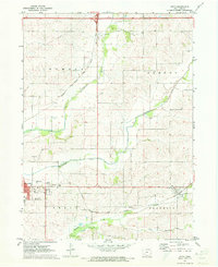 1971 Wiota1973 Print · USGSThe rural landscapes of Cass County are documented here in the early seventies, centered on the growing town of Atlantic and the East Nishnabotna River. Genealogists and historians can trace rail routes along the Chicago Rock Island and Pacific or locate local landmarks like the Drive-in Theater and Lorah Cem.
 - 1971 Map of Atlantic, 1973 Print
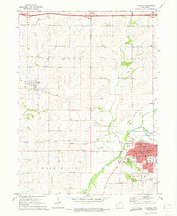 1971 Atlantic1973 Print · USGSCass County agriculture and rail commerce converge at the junction of the CHICAGO ROCK ISLAND AND PACIFIC in the early 1970s. Genealogists and local historians can locate rural landmarks like Buck Creek Ch, Brighton Cem, and the town's numerous district schools.
End of results
Showing maps 1-2 of 2
Top cities near Atlantic
- Griswold historical maps
- Exira historical maps
- Walnut historical maps
- Elk Horn historical maps
- Lewis historical maps
- Kimballton historical maps
See more
Top neighborhoods of Atlantic
Frequently asked questions
- What are the different types of historical maps available for Atlantic?
- What is the oldest map of Atlantic?
- Where can I purchase historical maps of Atlantic for my home or office?
- Where can I download high-res historical maps of Atlantic?
- Are there historical topographic maps available for Atlantic?
- Is there historical aerial imagery available for Atlantic?
- Where are historical maps of Atlantic sourced from?