1980s Maps of Westgate, Iowa
Explore 3 historic maps of Westgate from the 1980s. These maps offer a rare glimpse into what life looked like during the 1980s — showing old roads, neighborhoods, homes, and landmarks that have changed or disappeared over time.
Whether you're researching your family's past, planning a metal detecting trip, or studying how Westgate's landscape evolved across the 1980s, these high-resolution maps are a powerful tool for exploring the history of this region.
- Focus on a specific era: All maps on this page are from the 1980s, giving you a focused view of this time period.
- See what’s changed: Compare century-old streets, trails, and buildings to today's modern landscape using overlays and satellite layers.
- Research with precision: Use these maps for genealogy, historical research, land use analysis, or educational projects.
- View, download, or print: Maps are fully viewable online in high resolution, and can be downloaded or printed for your own records.
Start exploring Westgate's history through authentic maps from the 1980s. This is your window into the past.
Westgate, IA maps
(3)- 1981 Map of Maynard, 1982 Print
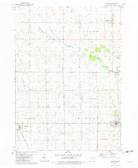 1981 Maynard1982 Print · USGSFayette County agricultural life is captured here in the early eighties, centered on the rail-linked communities of Maynard and Westgate. Researchers can trace the Chicago and North Western line or locate family sites near Calvary Cem and Union Ch.
 - 1984 Map of Oelwein, 1985 Print
 1984 Oelwein1985 Print · USGSNortheast Iowa and the Mississippi riverfront appear in detail during the 1980s, showing a land defined by deep river valleys and high ridges. Genealogists and historians can trace the Chicago and North Western rail line and locate rural sites like St Sebald Ch and Quaker Mill Pond.2 unique versions available
 - 1984 Map of Waverly, 1985 Print
 1984 Waverly1985 Print · USGSNortheast Iowa in the mid-eighties shows a robust network of river towns and rail corridors connecting agricultural centers. Researchers can trace family sites near Garden of Memories Cem or follow the Chicago and North Western line through Janesville and Waverly.2 unique versions available
End of results
Showing maps 1-3 of 3
Top cities near Westgate
- Oelwein historical maps
- West Union historical maps
- Sumner historical maps
- Fayette historical maps
- Fairbank historical maps
- Fredericksburg historical maps
See more
Frequently asked questions
- What are the different types of historical maps available for Westgate?
- What is the oldest map of Westgate?
- Where can I purchase historical maps of Westgate for my home or office?
- Where can I download high-res historical maps of Westgate?
- Are there historical topographic maps available for Westgate?
- Is there historical aerial imagery available for Westgate?
- Where are historical maps of Westgate sourced from?