1980s Maps of Utopia Park, Fairfield
Explore 2 historic maps of Utopia Park from the 1980s. These maps offer a rare glimpse into what life looked like during the 1980s — showing old roads, neighborhoods, homes, and landmarks that have changed or disappeared over time.
Whether you're researching your family's past, planning a metal detecting trip, or studying how Utopia Park's landscape evolved across the 1980s, these high-resolution maps are a powerful tool for exploring the history of this region.
- Focus on a specific era: All maps on this page are from the 1980s, giving you a focused view of this time period.
- See what’s changed: Compare century-old streets, trails, and buildings to today's modern landscape using overlays and satellite layers.
- Research with precision: Use these maps for genealogy, historical research, land use analysis, or educational projects.
- View, download, or print: Maps are fully viewable online in high resolution, and can be downloaded or printed for your own records.
Start exploring Utopia Park's history through authentic maps from the 1980s. This is your window into the past.
Utopia Park, Fairfield maps
(2)- 1980 Map of Fairfield North, 1981 Print
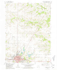 1980 Fairfield North1981 Print · USGSJefferson County in the early eighties reveals the growth of Fairfield alongside its academic and agricultural roots. Genealogists and historians can locate Evergreen Cem, trace the Old Railroad Grade, and explore the rural community of Perlee.
 - 1984 Map of Muscatine, 1985 Print
 1984 Muscatine1985 Print · USGSThe Mississippi River corridor and Iowa prairie meet in the 1980s, showcasing a landscape of river navigation and agricultural heartland. Genealogists and researchers can locate old schools and landmarks like Maharishi International University, Elm Grove Cem, and Lock & Dam No 16.2 unique versions available
End of results
Showing maps 1-2 of 2
Frequently asked questions
- What are the different types of historical maps available for Utopia Park?
- What is the oldest map of Utopia Park?
- Where can I purchase historical maps of Utopia Park for my home or office?
- Where can I download high-res historical maps of Utopia Park?
- Are there historical topographic maps available for Utopia Park?
- Is there historical aerial imagery available for Utopia Park?
- Where are historical maps of Utopia Park sourced from?